
Bhubaneswar: The well-marked low pressure over westcentral Bay of Bengal moved north-northwestwards has concentrated into a depression, the India Meteorological Department (IMD) informed on Wednesday evening.
The system was about 400 km east-southeast of Visakhapatnam (Andhra Pradesh), 420 km south-southeast of Gopalpur (Odisha), 450 km south of Puri (Odisha) and 500 km south of Paradip (Odisha) at 11.30 am. It is very likely to continue to move north-northwestwards, intensify further into a deep depression and cross Odisha and adjoining Andhra Pradesh coasts between Gopalpur and Paradip in the early hours of October 3, it added.
Under its influence, heavy rain accompanied by thunderstorm/lightning and gusty surface wind speed reaching 40-50 kmph may occur at one or two places in the districts of Koraput and Malkangiri on October 1.
The IMD has also issued yellow warning of heavy rain accompanied by thunderstorm/lightning and gusty surface wind speed reaching 40-50 kmph for one or two places in Puri, Ganjam, Gajapati, Rayagada, Kandhamal, Kalahandi, Nabarangpur, Nayagarh, Khurda and Cuttack. Thunderstorm/lightning and gusty surface wind speed reaching 30-40 kmph may also occur at one or two places in Mayurbhanj, Balasore, Bhadrak, Kendrapada, Jagatsinghpur, Jajpur, Dhenkanal, Keonjhar, Angul, Boudh, Deogarh, Sambalpur, Sundargarh, Jharsuguda, Bargarh, Nuapada, Balangir and Sonepur districts.
Red warning for October 2
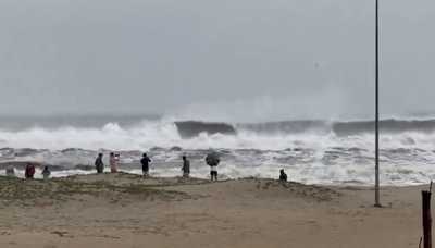
Heavy to very heavy rainfall with isolated extremely heavy falls along accompanied by thunderstorm/ lightning and gusty surface wind speed reaching 40-50 kmph gusting to 60 kmph is likely in the districts of Jagatsinghpur and Puri.
Orange warning of isolated heavy to very heavy rainfall along with thunderstorm/lightning and gusty surface wind speed reaching 40-50 kmph has been issued for one or two places in Kalahandi, Kandhamal, Bolangir, Nayagarh, Gajapati, Ganjam, Mayurbhanj, Khurda, Cuttack, Dhenkanal, Jajpur, Bhadrak, Balasore and Kendrapada.
Isolated heavy rainfall along with thunderstorm/lightning and gusty surface wind speed reaching 40-50 kmph is also likely in Malkangiri, Koraput, Rayagada, Nabarangpur, Bargarh, Sonepur, Boudh, Angul and Keonjhar districts. There is also a warning of thunderstorm/lightning accompanied by gusty surface wind speed reaching 30-40 kmph for one or two places in Nuapada, Sundargarh, Jharsuguda, Sambalpur and Deogarh.
The intensity of rain may gradually decrease thereafter.
On October 3, heavy to very heavy rainfall along with thunderstorm/lightning and gusty surface wind speed reaching 40-50 kmph may occur at one or two places in Nabarangpur, Nuapada and Bargarh districts.
Heavy rainfall along with thunderstorm/lightning and gusty surface wind speed reaching 30-40 kmph is also likely at one or two places in Mayurbhanj, Keonjhar, Sundargarh, Deogarh, Jharsuguda, Sambalpur, Sonepur, Balangir and Kalahandi. Thunderstorm/lightning accompanied by gusty surface wind speed reaching 30-40 kmph may also occur at one or two places in Puri, Khurda, Nayagarh, Ganjam, Gajapati, Bhadrak Balasore Jagatsinghpur, Jajpur, Kendrapada, Cuttack, Dhenkanal, Malkangiri, Angul, Koraput, Rayagada, Boudh, and Kandhamal.
Squally wind speed reaching 40-50 gusting to 60 kmph may also prevail over central & adjoining north Bay of Bengal on October 1. It would gradually increase, becoming 55-65 gusting to 75 kmph over westcentral and adjoining northwest Bay of Bengal from noon of October 2 noon to October 3 early morning.
Though there is no heavy rain warning thereafter, thunderstorm/lightning and gusty surface wind speed reaching 30-40 kmph may continue in districts of Sundargarh, Jharsuguda, Bargarh, Sambalpur, Deogarh, Angul, Dhenkanal, Keonjhar, Mayurbhanj, Balasore, Bhadrak, Jajpur, Kendrapada, Cuttack, Jagatsinghpur, Puri, Khurda, Nayagarh, Ganjam and Gajapati on October 4-5.