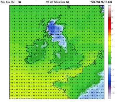
Brits are gearing up for extreme weather conditions as parts of the UK are likely to be blasted by snow blizzards in the next few days. Weather maps from WXCharts show wintry conditions are likely to impact areas as far as Birmingham, with temperatures plummeting to -10C in some parts of the country.
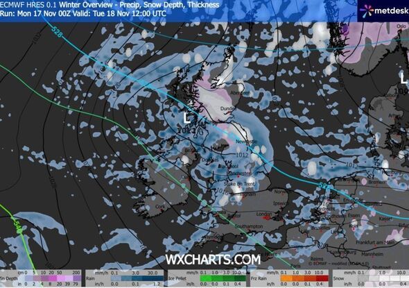
Weather charts show the snowy conditions will begin to hit the country at around 3am on Tuesday, with the wintry conditions first hitting Scotland. Parts of Glasgow, Perth, Dundee, and Edinburgh are likely to be covered by snow by around 6am. As the day progresses, snow showers will begin spreading across the country, and by 9am, cities such as Newcastle and York will be a witness to the unsettled weather. The colder weather front will even leave the areas around Birmingham, Manchester, and Stoke-on-Trent covered under the snow, with the temperature levels oscillating between -1C and 0C during the period, the maps have suggested. It comes with the Met Office issuing a series of weather warnings for snow and ice, in place from 5am on Tuesday until midday, while also warning that the wintry weather could continue until Thursday.
Met Office Deputy Chief Forecaster Tom Crabtree explained: "Wednesday to Friday will be the coldest part of the week, and this period has the greatest potential for impactful weather, with multiple warnings in place. Overnight, temperatures could get down to minus ten, with a significant wind chill from the strong northerly wind making things feel even colder.
"Wintry snow showers are expected to extend south through Wednesday and into Thursday, mainly affecting north-facing coastal areas. Snow accumulations are possible, including 2-5 cm in some low-lying areas in the north and east, where showers are frequent. On hills in parts of Northern Ireland, the northeast of England, and Scotland, 5-10cm of snow could fall, and accumulations of 15-20cm are possible above 300 metres in parts of northeastern England and Scotland.
"Although many places will see plenty of sunshine, daytime temperatures will be well below average, with a widespread frost setting in during the evening, especially in sheltered areas.
"With sub-zero temperatures in the first 'cold snap' of the year, updates to the current warnings are possible, so its important people keep up to date with the forecast."
The UK Health Security Agency (UKHSA) has also issued an amber Cold-Health Alert (CHA) for the Yorkshire & Humber, North West, and North East regions of England.
All other regions in England will be under a yellow alert from 12pm on Monday to 8am on Saturday.
Dr Agostinho Sousa, Head of Extreme Events and Health Protection at UKHSA, said: "This is the first prolonged cold spell of the season, and it is therefore vital to check in on friends, family, and neighbours who are most vulnerable.
"The forecasted temperatures can have a serious impact on the health of some people, leading to increased risk of heart attacks, strokes, and chest infections, particularly for individuals over the age of 65 and those with pre-existing health conditions."