In recent days, terrible earthquake tremors were recorded from Dhaka in Bangladesh to Kolkata in India. After this, an international earthquake research team has discovered a new active underground fault line in Bangladesh. This fault line starts from Jamalpur and Mymensingh in Bangladesh and extends to Kolkata in India. Its length is about 400 kilometers. Since this is an active fault line, it means that there is a risk of earthquake in this area.
It has also been said that a part of the fault line in Bangladesh is seismically active, that is, it Earthquake can cause. Studies have shown that this fault line is capable of producing earthquakes of up to magnitude 6.
Seismologists say that there are two main fault lines in Bangladesh. One of these is Dawki fault line and the other is Indo-Burma megathrust. Apart from this, other fault lines like Sitakunda coastal fault line, Madhupur, Shahjibazar, Jaflong and Comilla are also present in the country. After this, another fault line has now emerged.
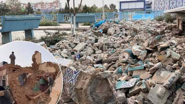
Many tremors have been felt in Bangladesh recently. Four earthquakes occurred in Bangladesh on 21 and 22 November. The earthquake of November 21 was of 5.7 magnitude on the Richter scale. 10 people died in this earthquake.
The recently discovered fault line was identified during a study led by Akhtarul Ahsan, Deputy Director, Bangladesh Geological Survey. Along with him, many researchers from America, France, Türkiye and Bangladesh were also present in this study. This fault line was identified in this study.
Akhtarul Ahsan told that this fault line has been divided into three parts. One part of it has a risk of low intensity earthquake, the other part has a risk of high intensity earthquake and the third part has no earthquake risk. However, Akhtarul Ahsan did not clarify which part was more risky and which was less.
According to new research, the recently identified fault line was formed 56 million years ago. At that time this fault line was active, but after that it did not remain active for 23 million years. About 5.6 million years ago, this fault line became active again due to the rising of the hills of Meghalaya.
In 2010, a research conducted by seismologist Humayun Akhtar revealed that from 1548 to 2009, 33 powerful earthquakes occurred in Myanmar, Assam, Shillong and Bangladesh. The biggest earthquake among these occurred on June 12, 1897, whose intensity was 8.7. This earthquake destroyed approximately 3.9 lakh square kilometer area.