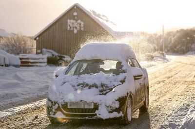
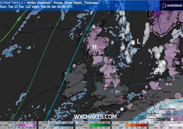
Britain could be set for a bone-chilling start to 2026 with a wall of snow stretching more than 660 miles from Scotland to London. The wintry curtain of cold conditions is predicted to cover the nation from midnight on Monday January 5, according to new maps from forecasters WXCharts.
As much as 10 to 20cm of snow could blanket the ground in some areas, with almost all of Scotland affected, as well as much of northern England, including cities such as Newcastle, York, Manchester and Stoke-on-Trent. In the south, parts of Greater London could see a rare flurry, as well as parts of Essex, Kent and Northamptonshire. The white stuff is expected to hang around throughout the day.
The cold start to 2026 comes as the Met Office confirmed 2025 is on track to be one of the UK's warmest years on record, joining 2022 and 2023 in the top three warmest years.
It said in a statement: "Currently the mean temperature value for the year so far (up to Sunday 21 December) is tracking well ahead of the previous highest year set in 2022.
"However, a forecast colder spell from Christmas and extending into 2026 makes it too close to call definitively."
A long-range forecast from the Met Office for December 28 up to January 6 said high pressure will likely dominate UK weather bringing cold dry conditions.
The forecast said: "This means that weather conditions will be largely settled and for many places it will remain dry. It may often be rather cloudy, but any rainfall that does develop is expected to be light with overall accumulations small.
"Winds will mostly be light with temperatures close to or slightly below normal. Into 2026, little change is anticipated through the first week of January, with settled and mainly dry conditions continuing for many parts of the UK.
"However, there is a small chance that more unsettled, wetter and milder weather could develop at times, particularly in the north."
Today:
Christmas Eve looks largely dry. Cloudy for a while in the south, and some cloud affecting eastern counties of England and Scotland. Otherwise sunny spells. Colder than of late, and brisk easterly winds adding to the chill in the south.
Tonight:
Generally dry with variable, sometimes large amounts of cloud. The clearest spells likely in the far south and west. Windy in the south. Patchy frost, with some fog northern Scotland.
Thursday:
Christmas Day will be mainly dry with some sunshine. Cloudier in the northeast and thicker cloud could give patchy rain across west Cornwall. Cold everywhere, and windy in the south.
Outlook for Friday to Sunday:
The weather will stay largely dry and settled on Boxing Day and during the weekend. Some clear or sunny spells. Remaining cold and still rather windy in the south.