Dozens of cities could be seeing snow in the coming days as an artic blast strikes the Britain, weather maps suggest. Forecast data collected by WXCHARTS.COM shows much of England, Wales, and Scotland with snow on the ground on Monday, January 5, with some areas seeing as much 13cm of snow depth.
Maps suggest there could be snow on the ground in parts of northern England and Scotland from New Year's Day. But by January 5, a blanket of snow fall could be covering multiple areasdown south as far as Folkestone in Kent, and as far north as Dunbeath, Caithness in Northern Scotland, some 600 miles away as the crow flies.
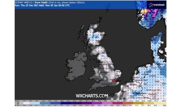
However, the snow coverage doesn't go all the way up Britain the length of Britain with parts of the the Northwest of England, the Midlands, south and southwest England, and parts of Scotland spared.
Snow depth in England looks set to range from between around 1cm to 6cm south of Newcastle, with Wales seeing around 1cm, the weather site's maps indicate.
In Scotland, snow depth could range from 1cm to 13cm around were the southeastern edge of the Highlands meets Aberdeenshire and Perth and Kinross.
The maps don't show any fallen snow in Northern Ireland at this time.
A number of major cities in England look set to see snow on the ground at midnight on January 5. The - non-exhaustive - list looks like it could include:
Snow looks set to be covering the majority of Scotland at this time. Major cities set for fallen snow could include:
Other major cities like Aberdeen and Dundee along the eastern coast could avoid snowfall on the ground at this time.
The deepest dumps of snow look set to be in Cairngorms National Park and the mountainous regions west of it. Large parts of Wales look set to have some snow on the ground in the north and down through the centre of the nation, but not in the country's largest population centres like Newport, Cardiff, Swansea, and Wrexham.
However, snowfall is notoriously difficult to predict, it's best to check forecasts nearer the time for a clearer picture.
The Met Office's long-range forecast covering this period (Monday, December 29 to Wednesday January 7 anticipates that high pressure is "likely to dominate across the UK through to the end of the year, centred to the west over the North Atlantic".
"This will likely maintain relatively settled conditions at first, but with a few showers possible along some coasts exposed to the northerly wind," it adds.
"Towards the first weekend of January, high pressure is likely to shift a little farther away from the UK, allowing a greater chance of more changeable conditions to develop.
"This will bring an increased risk of some rain or showers at times which, with cold air close to the UK, may bring some wintry hazards to some places. Temperatures will probably be near or slightly below average for this period overall."
Meanwhile, today (Christmas Day) is expected to be mostly dry with "sunny spells, especially in the south". "Parts of eastern Scotland and northeast England however probably rather cloudy at times, with perhaps an isolated shower," the Government agency adds, "Feeling cold, especially in the strong wind across the south."
Tonight is expected to bring a "dry Christmas night with long clear spells, although remaining cloudier over northeastern parts".
"A colder night with a widespread air frost, but winds beginning to ease a little."
A Yellow warning for wind is currently in place in dozens of local authorities across Southwest England and Wales until 23:59.
The Met Office warns: "East to northeasterly winds will become particularly strong and gusty during Christmas Day, with peak gusts fairly widely of 45-55 mph, but 55-65 mph along some exposed coasts and to the west of prominent hills.
"Given the more unusual wind direction, this may lead to some disruption to transport and power supplies. Large waves will be an additional hazard on some coasts."
You can find the latest list of affected areas and official guidance here.