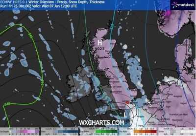
Weather maps suggest the UK could be hit by a huge wall of snow as 2026 gets off to a wintry start. The latest projections from forecaster WXCharts show snowfall stretching from the northern tip of mainland Scotland all the way down to towns on the south coast of England, such as Eastbourne and Hastings. John O'Groats to Dover on the coast of Kent is some 763 miles so it would be quite the battering if there is snow over such a huge chunk of the country.
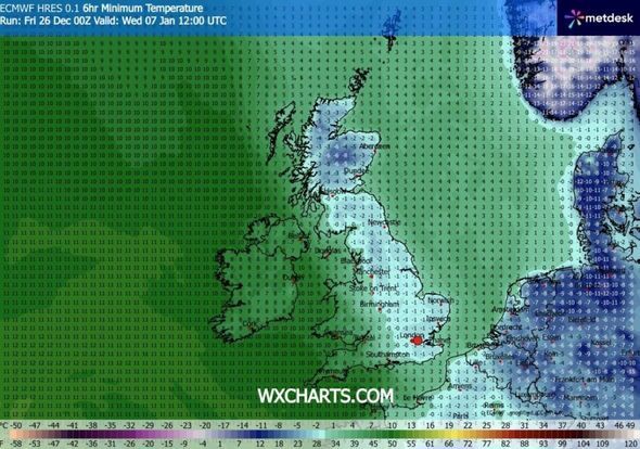
Meanwhile, temperatures are set to fall well below freezing, with conditions as low as -8C in some areas. Current maps show the vast majority of Scotland covered in snow, as well as the eastern two thirds of England. However, most of Wales and Northern Ireland are expected to escape the snow, WXCharts predicts. Snow arrives on Wednesday, January 7 according to its maps and is expected to last on and off for a few days, gradually disappearing as the week goes on. By Saturday, January 10, only small parts of England will still be getting snow.
The counties that WXCharts predicts will be hit by snow on January 7 are:
Scotland
England
The Met Officealways warns that accurately predicting snowfall more than a week away is notoriously difficult. This is because slight changes in temperatures can mean the difference between rain, snow and sleet.
Its own long-term forcast for December 30 to January 8 doesn't predict widespread snow but does say "wintry hazards" are possible.
It says: "High pressure is likely to dominate across the UK through to the end of the year, centred to the west or northwest over the North Atlantic.
"This will likely maintain relatively settled conditions at first, but with a little light rain or drizzle in places and a few showers possible along some coasts exposed to the northerly wind. Around the turn of the year, high pressure is likely to shift a little farther away from the UK, allowing a greater chance of more changeable conditions to develop.
"This will bring an increased risk of some rain or showers at times which, with cold air close to the UK, may bring some wintry hazards to some places. Temperatures will probably be near or slightly below average for this period overall."