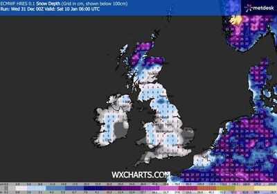

Britain could be plunged into a deep winter freeze with heavy snow and bitterly cold temperatures in just over a week, according to new weather maps. The latest ECMWF models from forecaster WXCharts, generated on December 31, indicate that large swathes of the UK will be covered in snow by Saturday, January 10, with accumulations reaching up to 42cm (approximately 16 inches) in the most affected areas, alongside temperatures dropping as low as -12C.
Snow depth charts indicate the harshest conditions are expected across Scotland, particularly the Highlands, where widespread totals of 30 to 40cm are shown, with locally higher amounts over higher ground. Parts of northern England, including the Pennines and North York Moors, also appear at risk of significant snowfall, with accumulations generally ranging between 10cm and 20cm. Just south of Newcastle, depths of between nine and 12cm are also predicted.
Further south, the maps suggest that a covering of snow could extend into the Midlands and parts of southern England, although amounts here are typically lower, at one to five centimetres, with higher totals again over hills in Wales and southwest England. Northern Ireland is also expected to see snowfall, with five to 10cm possible in some areas.
Alongside the snow, temperature charts paint a stark picture of a brutal Arctic blast. Minimum temperature maps for 6am on January 10, also generated on December 31, show that much of the UK will fall far below freezing, with a forecast of -7C to -12C across inland Scotland and northern England. Even southern areas, including Wales, London and South East England, could see lows of -2C to -4C, likely increasing the risk of widespread ice.
While long-range forecasts remain subject to change, if the models prove correct, parts of the UK could be facing one of the coldest and snowiest spells of the winter so far, with conditions more reminiscent of deep continental cold than a typical January in the UK.

Separately, the Met Office's most up-to-date long-range forecast for the period January 5 through to January 14 reads: "Cold northerly winds dominant across the UK in the first week of January bring wintry showers (often of snow) to many coastlines (and areas just inland of these) that are exposed to onshore winds.
"Into the new week more coherent bands of precipitation and thicker cloud will attempt to move in from the west, with a risk of further snow on the leading edge of these turning to rain. Confidence is low in the rate of this return to a more mild Atlantic flow, with a risk of further [arctic] airflows following fronts to resume wintry showers, especially across northern areas of the UK.
"Temperatures recovering to just below average for most, though further north more likely to return cold at times."
Regarding its long-term forecasting, the Met Office warns: "When looking at forecasts beyond five days into the future, the chaotic nature of the atmosphere begins to play a larger part - small events currently over the Atlantic can have potentially significant impacts on our weather in the UK in several days' time".


