Snow is set to return to the UK this Tuesday according to Met Office warnings - but it's later in the week when a larger chunk of the country will be affected.
The forecaster has issued a yellow weather warning for snow in parts of Scotland from Tuesday at midnight all the way to 3pm on Wednesday, February 4 as well as another snow warning for Tuesday and Wednesday in the Shetlands. But further south, in England, Wales and in Northern Ireland, snow will arrive on Thursday or Friday.
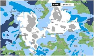
The latest snow maps issued by the weather experts now show that snow is set to fall in England and Wales on Thursday, with heavier snow showers arriving in the early hours of Friday morning.
It will follow a 39-hour yellow weather warning for north of the border.
Areas set for the heaviest snowfall in England at 3am on Friday, February 6 include Manchester, Sheffield, Birmingham, Stoke-on-Trent, Burnley and North Yorkshire. In Wales, Caernafon, Aberystwyth, Newtown and St Asaph are all forecast to see heavy snow at the sime time, as well as Newry and Enniskillen in Northern Ireland.
But several more parts of the country will see snowfall too including Caernafon in North Wales, Londonderry in Northern Ireland and Leeds.
The 13 areas of England most likely to see snow in the UK on Friday according to the Met Office are:
The Met Office said in its forecasts for Friday to Sunday: "Frontal systems over the Atlantic, steered by a south-shifted jet stream, are likely to approach the UK at times, but tending to stall as they encounter a blocking area of high pressure to the north and northeast. This will result in further spells of rain at times, falling in areas already sensitive to flooding.
"As these bands of rain spread northwards, some snow will be possible in northern England and Scotland, mainly over higher ground, as they encounter colder air. A subtle shift southwards of these areas of low pressure is anticipated during the second week of February, which may allow a greater chance of colder air to spread across larger parts of the UK, including the south, bringing an increased risk of wintry hazards for a time."