A massive blizzard could soon blanket nearly the entire UK in snow - with approximately 5% of the nation escaping the wintry conditions.
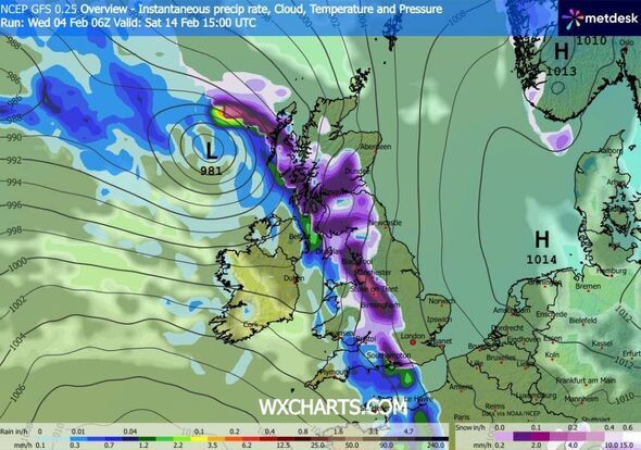
The GFS weather model indicates flurries striking Northern Ireland and Wales at around 9am on February 14, before progressing eastwards throughout the day and delivering snow to England and Scotland as well.
At approximately 3pm, the weather maps reveal a band of snow extending from the south coast of England to the far north of Scotland. Numerous major cities, including Southampton, Birmingham, Manchester, Liverpool, Edinburgh and Glasgow, could experience snow around this time.
London could witness snow at roughly 9pm as the weather front continues its eastward progression, also affecting Yorkshire and the north-east. It will subsequently move off into the North Sea, the maps indicate, leaving the nation blanketed.
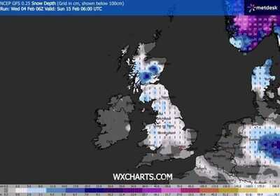
Snow coverage maps reveal almost the entire UK shaded in purple at 6am on February 15, signifying snow lying on the ground. Only limited areas of Northern Ireland, the south-west, East Anglia and the northern coasts of Scotland are depicted with no snow.
As much as 19cm (approximately seven inches) could accumulate on hills in northern Scotland, the data indicates, with 5cm to 6cm (roughly two inches) possible in northern England, the Midlands and Wales.
BBC Weather also suggests snow could arrive later this month.
Its forecast for February 9 to 15 states: "Changeable conditions are expected. England and Wales should expect normal or above average amounts of rainfall, with further risks of some heavy rain and local risks of flooding, especially in south-western areas.
"The northern edges of any precipitation bands will still be susceptible to snow as they move into the colder air, mostly on northern hills.
"The northward extent remains uncertain but there will be wintry showers across northern regions nonetheless, potentially to lower levels in Scotland, although here the north-west should be drier than normal."
The Met Office says for February 9 to 18: "Cyclonic patterns are expected to dominate across the UK during mid-February. Frontal systems over the Atlantic are likely to approach the UK at times, tending to become slow moving as they encounter a blocking area of high pressure to the northeast.
"This will result in showers or longer spells of rain spreading across the UK, these heavy at times. Rainfall amounts will probably be highest in parts of the west, including across areas already sensitive to flooding.
"As these bands of rain spread northwards, snow is possible across northern England and Scotland, mainly over high ground. Strong winds could develop in places, especially coasts. Temperatures will probably be close to normal overall, with any cold conditions more likely in the north."