
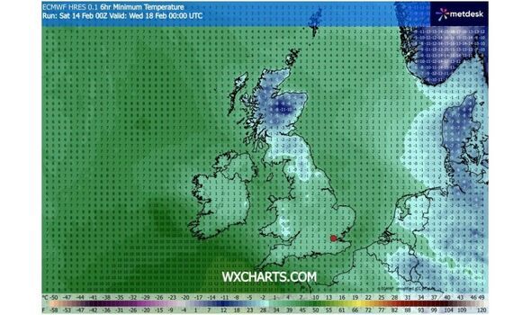
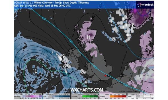
Parts of the UK could be shivering in -13C temperatures in days as snow and rain pelts the British Isles, weather maps suggest. Data collected by forecaster WXCHARTS.COM shows almost the whole of Scotland with at least 50cm of snow on the ground on Wednesday, February 18.
In an area intersecting Angus, Aberdeenshire, Perth and Kinross, snow depth could be considerably higher, a Winter Overview map showing precipitation, snow depth, and thickness suggests. Minimum temperatures in Scotland look set to range from 2C and down as low as 13C in an area intersecting Argyle and Bute, Sterling, and Perth and Kinross, the maps indicate. In England, the northern-most parts of the North West, as well as the North East and down into Yorkshire and the Humber could also have snow on the ground at this time.
Meanwhile, snow is expected in eastern Cornwall as precipitation hits the southwestern tip of England, though the minimum temperature there could be among the least cold in the country.
Temperatures look set to range from around 4C in the South West down as low as -5C in the northern most parts of England.
In Wales, there could be active snowfall around Pembrokeshire in the southwest of the country. Temperatures in Wales look set to range between 2C in Pembrokeshire, and -2C elsewhere.
The mercury could drop to between 3 and -1C in Northern Ireland, though the maps don't show active or fallen snow at this time.
Separately, the Met Office's 3-5 day forecast, covering Tuesday, February 17 to Thursday, February 19, anticipates: "Drier on Tuesday, with sunny spells. An increasing risk of rain and perhaps some hill snow on Wednesday and into Thursday in the south. Mostly dry elsewhere. Frosty nights."
Meanwhile, a yellow weather warning for snow and ice covering dozens of local authorities across Scotland and England remains in effect until 10am today.
*** Ensure our latest news headlines always appear at the top of your Google Search by making us a Preferred Source. Click here to activate or add us as Preferred Source in your Google search settings. ***
UK areas affected: Central, Tayside & FifeResidents in affected areas are warned that snow, "heavy at times, may cause some disruption to travel, especially over high ground during Saturday night and Sunday morning".
A second yellow weather warning for snow will be in place from 10am today covering the following regions and local authorities:
East Midlands"The rain may be heavy at times and it will be windy in coastal areas. Additional warnings may be required. We encourage the public to keep up to date with the latest forecasts and any warnings that may be issued."
You can find the most up to-date Met Office weather warnings and guidance here.