Many of us learned in school that Earth has seven continents, and the map seemed finished and unchanging. However, scientists have found something beneath the southwest Pacific that changes that view. Zealandia is a huge landmass that fits the scientific definition of a continent, even though almost all of it is underwater.
Zealandia covers about 4.9 million square kilometers, making it about two-thirds the size of Australia. Only a small part of it is above sea level, which forms New Zealand and New Caledonia. The rest is hidden under deep ocean water.
This isn’t a case of suddenly finding a lost land. Instead, it’s about gaining a better understanding of something that has always existed.
What Makes a Continent in the First Place
The debate about Zealandia centers on one main question: What really makes something a continent?
Geologists don’t just look at what’s above sea level. They focus on the type of crust. Continental crust is thicker and less dense than oceanic crust, usually between 30 and 70 kilometers thick, while oceanic crust is about 5 to 10 kilometers thick. Continental crust also has different rocks, like granites and metamorphic rocks, instead of the basalt found on most of the ocean floor.
In 2017, geologist Nick Mortimer and his team published an important paper in GSA Today. They argued that Zealandia meets the main scientific standards for a continent. Their research showed that Zealandia has the right thickness, rock types, elevation, and clear boundaries. They described it as one large piece of continental crust, not just scattered bits.
This study helped end years of debate and officially recognized Zealandia as a continent from a geological point of view.
How Do You Study a Continent You Cannot See
Unlike other continents, most of Zealandia is underwater, so you can’t stand on it. So how do scientists study it?
The answer is marine geophysics. Scientists use seismic reflection, which sends sound waves into the Earth and measures how they bounce back. This shows the thickness and structure of the crust under the ocean. They also use gravity measurements to spot differences in rock density, which helps tell continental crust from oceanic crust.
Rock samples from the ocean floor give more evidence. Scientists have found granites and high-grade metamorphic rocks, which are common in continental areas. These results fit what geologists expect from a real continent.
In 2023, researchers at GNS Science finished the most detailed geological map of Zealandia so far. They used years of marine surveys, seismic data, and rock studies to show its boundaries and features clearly. This mapping made the scientific case even stronger and filled in important missing details.

A Story That Began With Gondwana
Zealandia’s story goes back over 100 million years. In the Cretaceous period, it was part of the southern supercontinent Gondwana, joined with Antarctica and Australia.
As tectonic forces slowly broke Gondwana apart, Zealandia split off. But unlike Australia, its crust stretched and became much thinner. Over millions of years, most of it sank below sea level.
Drilling expeditions by the International Ocean Discovery Program back up this timeline. Sediment cores and fossils show that parts of Zealandia were once above water before slowly sinking. These records help scientists understand how continents split and change over time.
Why This Matters Today
Calling Zealandia a continent is not just about naming it. Its structure affects plate tectonics in the southwest Pacific, an area with many earthquakes and volcanoes. Knowing the thickness and edges of its crust helps researchers better understand seismic risks near New Zealand.
Zealandia also affects how the ocean moves. Its underwater ridges and plateaus change currents, which in turn influence climate and marine life. Because it was separated from Gondwana for so long, New Zealand developed many unique species.
Researchers like Rupert Sutherland point out that studying Zealandia helps us learn how continents can stretch, thin out, and almost vanish under the sea. These processes are key to understanding how Earth’s surface changes.
Rethinking the Map Beneath Our Feet
The idea of a hidden continent changes how we picture the world. We usually think of continents as land above water, but geology shows that it’s the crust and tectonic features that matter, not just what we can see.
Zealandia shows us that much of our planet is still hidden under the oceans. New tools like seismic imaging, gravity mapping, and deep-sea drilling keep uncovering features we didn’t know were there.
The continent was always there. Science just updated the definition and helped us see the full picture.
Zealandia covers about 4.9 million square kilometers, making it about two-thirds the size of Australia. Only a small part of it is above sea level, which forms New Zealand and New Caledonia. The rest is hidden under deep ocean water.
This isn’t a case of suddenly finding a lost land. Instead, it’s about gaining a better understanding of something that has always existed.
What Makes a Continent in the First Place
The debate about Zealandia centers on one main question: What really makes something a continent?
Geologists don’t just look at what’s above sea level. They focus on the type of crust. Continental crust is thicker and less dense than oceanic crust, usually between 30 and 70 kilometers thick, while oceanic crust is about 5 to 10 kilometers thick. Continental crust also has different rocks, like granites and metamorphic rocks, instead of the basalt found on most of the ocean floor.
In 2017, geologist Nick Mortimer and his team published an important paper in GSA Today. They argued that Zealandia meets the main scientific standards for a continent. Their research showed that Zealandia has the right thickness, rock types, elevation, and clear boundaries. They described it as one large piece of continental crust, not just scattered bits.
This study helped end years of debate and officially recognized Zealandia as a continent from a geological point of view.
How Do You Study a Continent You Cannot See
Unlike other continents, most of Zealandia is underwater, so you can’t stand on it. So how do scientists study it?
The answer is marine geophysics. Scientists use seismic reflection, which sends sound waves into the Earth and measures how they bounce back. This shows the thickness and structure of the crust under the ocean. They also use gravity measurements to spot differences in rock density, which helps tell continental crust from oceanic crust.
Rock samples from the ocean floor give more evidence. Scientists have found granites and high-grade metamorphic rocks, which are common in continental areas. These results fit what geologists expect from a real continent.
In 2023, researchers at GNS Science finished the most detailed geological map of Zealandia so far. They used years of marine surveys, seismic data, and rock studies to show its boundaries and features clearly. This mapping made the scientific case even stronger and filled in important missing details.
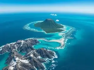
Most of Zealandia lies hidden beneath the southwest Pacific Ocean. Scientists use advanced marine geophysics to study this submerged continent. Its geological features confirm its continental status.
A Story That Began With Gondwana
Zealandia’s story goes back over 100 million years. In the Cretaceous period, it was part of the southern supercontinent Gondwana, joined with Antarctica and Australia.
As tectonic forces slowly broke Gondwana apart, Zealandia split off. But unlike Australia, its crust stretched and became much thinner. Over millions of years, most of it sank below sea level.
Drilling expeditions by the International Ocean Discovery Program back up this timeline. Sediment cores and fossils show that parts of Zealandia were once above water before slowly sinking. These records help scientists understand how continents split and change over time.
Why This Matters Today
Calling Zealandia a continent is not just about naming it. Its structure affects plate tectonics in the southwest Pacific, an area with many earthquakes and volcanoes. Knowing the thickness and edges of its crust helps researchers better understand seismic risks near New Zealand.
Zealandia also affects how the ocean moves. Its underwater ridges and plateaus change currents, which in turn influence climate and marine life. Because it was separated from Gondwana for so long, New Zealand developed many unique species.
Researchers like Rupert Sutherland point out that studying Zealandia helps us learn how continents can stretch, thin out, and almost vanish under the sea. These processes are key to understanding how Earth’s surface changes.
Rethinking the Map Beneath Our Feet
The idea of a hidden continent changes how we picture the world. We usually think of continents as land above water, but geology shows that it’s the crust and tectonic features that matter, not just what we can see.
Zealandia shows us that much of our planet is still hidden under the oceans. New tools like seismic imaging, gravity mapping, and deep-sea drilling keep uncovering features we didn’t know were there.
The continent was always there. Science just updated the definition and helped us see the full picture.