
Listen to this article in summarized format
Loading...
××
Subscribe to

Unlock AI Briefing and Premium Content
New Year Offer 24 Hours Left
Subscribe NowAlready a member? Sign In
What's Included
- Exclusive Stories
- Daily ePaper Access
- Smart Market Tools
- Curated Investment Ideas
- Ad-lite Experience
Subscription

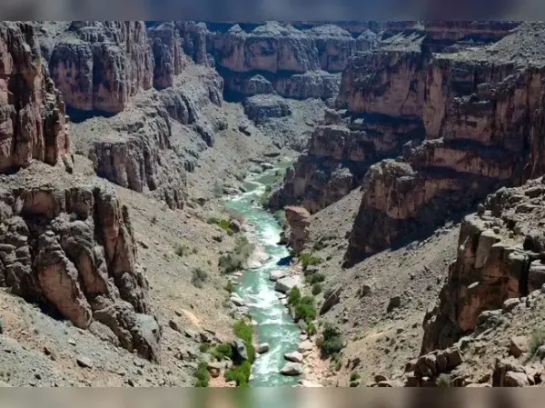
For more than a century, geologists have debated why the Green River cuts directly through the Uinta Mountains in Utah and Colorado rather than flowing around them. The river slices through peaks that rise more than 4,000 meters above sea level, creating deep canyons such as the Canyon of Lodore. At first glance, this landscape gives the impression that the river is flowing uphill through resistant terrain. Recent research, however, provides a geophysical explanation rooted deep within Earth’s interior.
In the late nineteenth century, explorer and geologist John Wesley Powell proposed that the Green River was antecedent, meaning it existed before the mountains rose and maintained its course as the land uplifted slowly. Later hypotheses suggested river capture or sediment buildup allowed the river to breach a divide. However, these explanations struggled to account for the age relationships between uplift, incision depth, and regional topography.
Lithospheric dripping occurs when dense material accumulates at the base of Earth’s lithosphere, which includes the crust and uppermost mantle. Over time, this dense mass can detach and sink into the underlying mantle due to gravitational instability. As it sinks, it pulls the overlying crust downward, creating a broad depression at the surface. When the dense material eventually detaches completely and continues descending, the overlying lithosphere rebounds upward due to isostatic adjustment. This process produces a cycle of subsidence followed by uplift that can reshape regional topography over millions of years.
River network analysis also reveals a radial pattern of uplift surrounding the Uinta Mountains. Such patterns are characteristic of rebound following a subsidence event. Modeling suggests that the drip likely detached between two and five million years ago, aligning with the period when the Green River established its modern course.
After the dense root detached and sank deeper into the mantle, the surface rebounded upward. The mountains rose around the already established river channel. The river then continued to incise downward as uplift progressed, maintaining its course through the rising terrain. In this view, the river did not climb over a mountain range. Instead, it occupied a path that predated the final uplift of the mountains to their current height.
The findings also demonstrate that surface landscapes can record processes occurring hundreds of kilometers beneath Earth’s surface. Lithospheric dripping, once considered rare or difficult to document, may explain other regions where rivers cut across resistant highlands in unexpected ways. Geologists increasingly recognize that rivers act as recorders of tectonic and mantle-driven change. By studying river incision patterns and timing, researchers can infer deep-Earth dynamics that would otherwise be invisible.
This explanation resolves a 150-year-old geological mystery and illustrates how processes far beneath Earth’s crust can shape the surface in subtle yet profound ways. What once appeared to be a river challenging topography is now understood as evidence of a dynamic planet whose interior and surface remain closely connected.
Image Credit: x/@grok
The Geological Puzzle
Rivers normally follow the path of least resistance. They flow downhill, avoid high ridges, and gradually carve valleys through softer rock. The Uinta Mountains formed roughly 50 million years ago during tectonic uplift associated with the Laramide orogeny. Yet geological dating suggests that the modern course of the Green River through these mountains developed far later, within the past 10 million years. This mismatch in timing posed a fundamental question. If the mountains were already high, how did the river establish a path straight through them rather than being diverted around them?In the late nineteenth century, explorer and geologist John Wesley Powell proposed that the Green River was antecedent, meaning it existed before the mountains rose and maintained its course as the land uplifted slowly. Later hypotheses suggested river capture or sediment buildup allowed the river to breach a divide. However, these explanations struggled to account for the age relationships between uplift, incision depth, and regional topography.
A New Explanation From Deep Earth
Recent work led by Dr. Adam Smith of the University of Glasgow, published in the Journal of Geophysical Research: Earth Surface, proposes a different mechanism. The researchers argue that the river did not flow uphill. Instead, the land beneath the Uinta region temporarily subsided due to a deep mantle process known as lithospheric dripping.Lithospheric dripping occurs when dense material accumulates at the base of Earth’s lithosphere, which includes the crust and uppermost mantle. Over time, this dense mass can detach and sink into the underlying mantle due to gravitational instability. As it sinks, it pulls the overlying crust downward, creating a broad depression at the surface. When the dense material eventually detaches completely and continues descending, the overlying lithosphere rebounds upward due to isostatic adjustment. This process produces a cycle of subsidence followed by uplift that can reshape regional topography over millions of years.
Seismic and Geological Evidence
The lithospheric drip model is supported by several independent observations. Seismic tomography data, which use earthquake waves to image structures deep within Earth, reveal a dense, cold anomaly roughly 200 kilometres beneath the Uinta region. This structure is consistent with a detached lithospheric drip that has sunk into the mantle. Measurements of crustal thickness in the area show that the crust beneath the Uintas is thinner than expected for mountains of that elevation. This thinning is consistent with the removal of material from the base of the lithosphere.River network analysis also reveals a radial pattern of uplift surrounding the Uinta Mountains. Such patterns are characteristic of rebound following a subsidence event. Modeling suggests that the drip likely detached between two and five million years ago, aligning with the period when the Green River established its modern course.
How the River’s Course Was Set
According to this model, when the lithosphere beneath the Uintas was being pulled downward by the sinking dense root, the surface elevation in the region temporarily decreased. During this period of relative depression, the Green River could carve across the area without encountering a high mountain barrier.After the dense root detached and sank deeper into the mantle, the surface rebounded upward. The mountains rose around the already established river channel. The river then continued to incise downward as uplift progressed, maintaining its course through the rising terrain. In this view, the river did not climb over a mountain range. Instead, it occupied a path that predated the final uplift of the mountains to their current height.
Broader Geological Implications
Dr. Smith and colleagues emphasize that solving the Green River mystery has broader implications for understanding continental evolution. The integration of the Green and Colorado rivers reshaped the continental divide in western North America, influencing long-term drainage patterns and sediment transport.The findings also demonstrate that surface landscapes can record processes occurring hundreds of kilometers beneath Earth’s surface. Lithospheric dripping, once considered rare or difficult to document, may explain other regions where rivers cut across resistant highlands in unexpected ways. Geologists increasingly recognize that rivers act as recorders of tectonic and mantle-driven change. By studying river incision patterns and timing, researchers can infer deep-Earth dynamics that would otherwise be invisible.
Conclusion
The Green River does not flow uphill against gravity. Instead, its path reflects a complex interaction between surface erosion and deep mantle processes. Lithospheric dripping temporarily lowered the landscape, allowing the river to establish its course before regional uplift restored the mountains to their present elevation.This explanation resolves a 150-year-old geological mystery and illustrates how processes far beneath Earth’s crust can shape the surface in subtle yet profound ways. What once appeared to be a river challenging topography is now understood as evidence of a dynamic planet whose interior and surface remain closely connected.