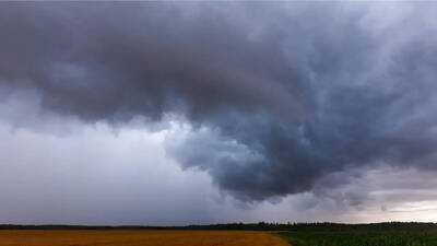
The National Weather Service has announced a tornado watch for multiple counties in western Pennsylvania, cautioning residents about potential severe weather conditions lasting until Thursday night. This watch is valid until 11 PM and encompasses counties including Allegheny, Armstrong, Beaver, Butler, Lawrence, Mercer, Venango, Washington, and Westmoreland. Additionally, a separate alert has been issued for Crawford and Erie counties later in the evening.
The tornado watch covers a significant portion of western Pennsylvania. Meteorologists anticipate that storms will start after 6 PM on Thursday, potentially continuing into the early hours of Friday. Both Thursday and Friday have been designated as alert days, with the most severe weather expected overnight. During this period, the region may experience heavy rainfall and isolated strong to severe thunderstorms.
Rainfall amounts could surpass one inch in many areas, with some regions between Interstate 80 and Interstate 70 possibly receiving between 1.5 and 2 inches. These conditions heighten the risk of water accumulation in low-lying areas.
A tornado watch indicates that conditions are favorable for tornado formation. While not every location will experience a tornado, some areas may be at risk. Strong winds associated with these storms can cause damage to trees and power lines, along with the potential for lightning and heavy rainfall.
Localized flooding is a significant concern, particularly during the overnight hours into Friday morning, which could make roads hazardous for morning commuters. Drivers may encounter water-covered streets in certain areas.
Conditions are expected to improve by early Friday morning, with the region beginning to dry out around 8 AM, providing relief after a night of severe weather threats.