Scientists have produced the most detailed map of the land that has been buried under the ice sheet in Antarctica, showing that it has a complex geography that has remained invisible for decades due to the extreme conditions and the limitations of technology.
This new map was produced by a new technique called Ice Flow Perturbation Analysis, or IFPA, which has helped scientists understand the geography of the bedrock buried under the thick ice sheet that reaches several kilometers in depth, according to Live Science.
This new map has revealed that the continent of Antarctica has a diverse geography that consists of sharp ridges, deep valleys, and extensive river systems flowing underneath the ice sheet, showing that it is not a flat frozen desert as previously thought.
This new information has helped the scientific community understand the geological history of the continent, as well as the relationship between the ice sheet and the geography of the land, according to Space.
Using this method, scientists can map areas they have not physically seen, which is important in Antarctica. According to Space and AOL, IFPA is an innovative method for creating maps by using satellite imagery and physical models. The key to this method is that it can be revised over time as satellite imagery becomes available. The importance of this is that it does not require scientists to physically venture into these areas.
Space states that the role played by the lakes and valleys in the movement of the ice is significant, as the water under the ice acts as a lubricant, which speeds up the movement of the glaciers.
Mid Day states that the observations made by the scientists also provide valuable information regarding the tectonic movements as well as the climate in Antarctica before the ice cover.
The fact that tectonic boundaries exist in Antarctica implies that the continent has a dynamic history, which will affect future studies carried out on the geological evolution of the Earth.
The accuracy of the models used to make predictions regarding the rise in sea levels can be improved with the help of these maps. According to Space and Mid Day, the new data can also help climate change researchers better understand the grounding lines, which are the zones where the ice starts to float and break away into the ocean.
The grounding lines are very important in the context of climate change, as they determine the rate at which the ice breaks away into the ocean, resulting in a rise in sea levels, which in turn affects the coastal regions in the United States and other countries.
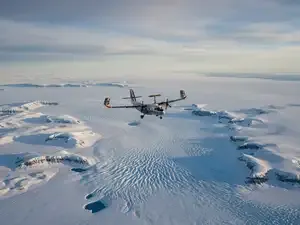
As reports from Live Science and AOL indicate, satellite technology has made it possible for scientists to monitor Antarctica at all times. This has reduced the need for dangerous expeditions that were previously conducted in order to monitor the region.
The use of satellite technology has revolutionized how scientists carry out research in the polar regions.
According to Space, future collaborations, including the International Polar Year 2031-2033, will bring together scientists from all over the world to further expand this research. The goal is to eventually merge geological research, climate modeling research, and ice dynamics research into one system in order to better understand how Antarctica will change in the future as the planet gets warmer.
As Live Science explains, these findings are a critical key to understanding how the ice sheet behaves today and how it might behave in the future.
In finding out what lies beneath the ice, we are finding the tools to better understand sea level rise and its effect on our communities. This hidden world, until now completely inaccessible, is now becoming one of the most important pieces in the climate jigsaw.
This new map was produced by a new technique called Ice Flow Perturbation Analysis, or IFPA, which has helped scientists understand the geography of the bedrock buried under the thick ice sheet that reaches several kilometers in depth, according to Live Science.
This new map has revealed that the continent of Antarctica has a diverse geography that consists of sharp ridges, deep valleys, and extensive river systems flowing underneath the ice sheet, showing that it is not a flat frozen desert as previously thought.
This new information has helped the scientific community understand the geological history of the continent, as well as the relationship between the ice sheet and the geography of the land, according to Space.
A New Way to See Through Ice
The key to this discovery is IFPA, which is an innovative method for studying how ice flows across the continent and how it reacts to the terrain it is covering. Rather than digging through the ice, scientists can use changes in how the ice is flowing to measure the shape of the bedrock.Antarctica map
Hidden Mountains, Valleys, and Lakes
The new map also shows mountain ranges buried under the ice, as well as deep valleys, which influence the flow of the glaciers across the continent. Other features also observed by the scientists include the existence of subglacial lakes, which are not exposed to the sun or the atmosphere.Space states that the role played by the lakes and valleys in the movement of the ice is significant, as the water under the ice acts as a lubricant, which speeds up the movement of the glaciers.
Mid Day states that the observations made by the scientists also provide valuable information regarding the tectonic movements as well as the climate in Antarctica before the ice cover.
The fact that tectonic boundaries exist in Antarctica implies that the continent has a dynamic history, which will affect future studies carried out on the geological evolution of the Earth.
Why This Matters for Sea Levels
The shape of the land under the ice needs to be understood in order to make accurate predictions regarding the effect of climate change on the ice sheet in Antarctica. The flow of ice also depends on the shape of the land, as it influences the rate at which the ice flows toward the ocean.The accuracy of the models used to make predictions regarding the rise in sea levels can be improved with the help of these maps. According to Space and Mid Day, the new data can also help climate change researchers better understand the grounding lines, which are the zones where the ice starts to float and break away into the ocean.
The grounding lines are very important in the context of climate change, as they determine the rate at which the ice breaks away into the ocean, resulting in a rise in sea levels, which in turn affects the coastal regions in the United States and other countries.
The Role of Advanced Satellite Technology
This is made possible by satellite technology that is sensitive to small changes in the height of the ice. By employing this technology, scientists are able to monitor changes in the ice sheet.As reports from Live Science and AOL indicate, satellite technology has made it possible for scientists to monitor Antarctica at all times. This has reduced the need for dangerous expeditions that were previously conducted in order to monitor the region.
The use of satellite technology has revolutionized how scientists carry out research in the polar regions.
What Comes Next
Though this map is a great step forward, researchers say it is only the beginning in the quest for a better understanding of the hidden landscape in Antarctica. Future radar surveys are expected to further refine this map.According to Space, future collaborations, including the International Polar Year 2031-2033, will bring together scientists from all over the world to further expand this research. The goal is to eventually merge geological research, climate modeling research, and ice dynamics research into one system in order to better understand how Antarctica will change in the future as the planet gets warmer.
A Hidden World With Global Impact
The discovery of this hidden landscape fundamentally alters the way in which we understand Antarctica, not just as a frozen continent, but as an active environment shaped by geology and climate over millions of years.As Live Science explains, these findings are a critical key to understanding how the ice sheet behaves today and how it might behave in the future.
In finding out what lies beneath the ice, we are finding the tools to better understand sea level rise and its effect on our communities. This hidden world, until now completely inaccessible, is now becoming one of the most important pieces in the climate jigsaw.