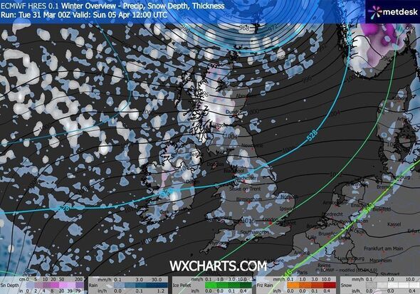
Britain is bracing for a wintry Easter weekend as unsettled conditions swoop across the country, bringing rain and snow. According to new maps by WXCHARTS, generated on March 31 using MetDesk data, rain will hit first in the late hours of Saturday, April 4, before snow is forecast to fall on Easter day.
Rain is due to drench the country on Saturday, April 4, coming in from the Atlantic and affecting areas of the UK along the coast, the new maps have suggested. In parts of southern Scotland - the worst-affected region of the country - there could be as much as 4mm/hr by 9pm on the day, the charts show.
The following day, the rain is forecast in the weather maps to move towards the east, drenching a major part of the UK, from Edinburgh in Scotland to Dorset in South West England - a whopping 400 miles.
Sunday is also expected to bring snow to large parts of Scotland and small parts of North West England, the maps suggest.
In Scotland, areas in the Highlands could get more than 1mm/hr by midday, while Manchester and Cumbria get up to 0.5mm/hr.
Separately, the Met Office forecast for Thursday to Sunday reads: "Rain clearing southeastwards on Thursday, then mostly fine.
"Further rain in the northwest later. Unsettled on Good Friday and Saturday. Spells of wet and windy weather sweeping across the UK."
Its Easter forecast adds: "It is increasingly likely that unsettled conditions will affect the UK over the Easter Holiday weekend, with the potential for strong winds and heavy rain at times.
"The wettest and windiest weather is more likely towards the west and north of the country."
The Met Office previously explained forecasting snow in the UK is more complex than in continental Europe due to rapidly-changing conditions. Its website read: "Small variations in temperature or wind direction can mean the difference between rain, sleet or snow. Meteorologists use high-resolution models to predict precipitation type, but these models can struggle with marginal situations where temperatures hover around freezing.
"Forecasters also consider factors such as precipitation intensity. Heavy bursts of precipitation can cool the air near the surface, increasing the chance of snow. Conversely, lighter precipitation may melt before reaching the ground. This fine balance makes snow forecasting one of the most uncertain aspects of UK weather prediction."