Some parts of the UK could see snow at the end of the month as the long period of unsettled weather continues.
A long-range forecast from the Met Office said that while sunny spells could reach the country first, northerly winds bringing wintry showers to northern and eastern coasts, and some snow could then return, especially in the north of Scotland.
The forecast, which covers Tuesday, April 21 to Thursday, April 30, read: "High pressure to the north of the UK will bring plenty of dry weather and sunny spells at first. A few scattered showers are possible in central and eastern areas.
"Parts of the east coast could be on the chilly side with low cloud and an onshore breeze, but further west it will feel quite warm, especially in sunnier areas. By the weekend, unsettled weather is signalled to return, but confidence in the details is low with a range of scenarios possible. One scenario is for a northerly wind bringing wintry showers to northern and eastern coasts, and some snow over Scottish mountains. If this does occur it will probably not last more than a few days, before high pressure attempts to return towards the end of the month."
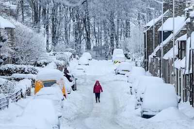
Other parts of the UK, however, could be hit by snow during the same period. Maps from WXCharts.com indicate a cold snap that could bring cold temperatures and snow to parts of the UK on Saturday, April 25.
The coldest areas will be in the north of the UK and will include Scotland and the north of England. Some areas of Scotland, especially around Aberdeen, could see up to 6cm of snow. Blizzards, however, could also hit as far south as Birmingham, the same maps show.
Other areas likely to be hit also include the north west of England, especially the Blackpool and Manchester area, which could be covered by 3cm of snow.
The weather in April so far has been unpredictable, with a series of mini heatwaves and cold snaps. These snow blizzards will be followed by a 23C scorcher on Wednesday, April 29, according to the latest forecast.
A Met Office forecast covering the period from April 21 to April 30 read: "High pressure to the north of the UK will bring plenty of dry weather and sunny spells at first. A few scattered showers are possible in central and eastern areas.
"Parts of the east coast could be on the chilly side with low cloud and an onshore breeze, but further west it will feel quite warm, especially in sunnier areas. By the weekend, unsettled weather is signalled to return, but confidence in the details is low with a range of scenarios possible.
"One scenario is for a northerly wind bringing wintry showers to northern and eastern coasts, and some snow over Scottish mountains. If this does occur, it will probably not last more than a few days before high pressure attempts to return towards the end of the month."