
The latest UK weather maps are turning icy blue showing an arctic blast that will bring freezing temperatures across large parts of the country.
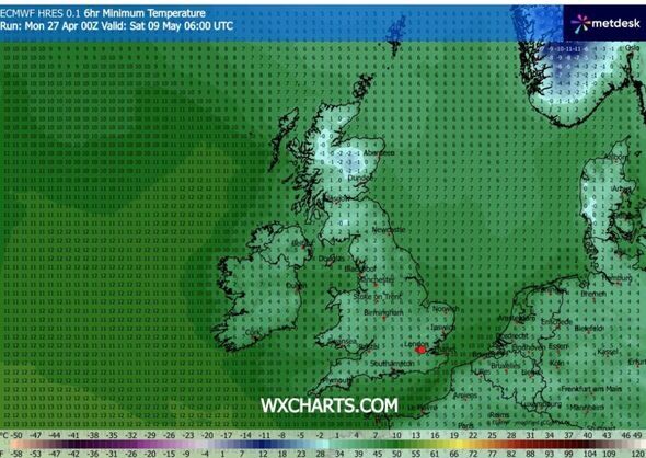
The latest maps from WXCharts show a cold weather blast hitting the UK in early May, bringing with it the possibility of freezing temperatures. The north of the country will be the coldest area with some places in Scotland likely to be hit by a cold snap that will bring temperature lows ranging from 0C to -3C at 6am on May 9, especially in the Aberdeen and Dundee areas. The maps suggest it could be extremely cold across the rest of the country as well in many other areas, including the south of England, with the coldest temperatures only just getting above freezing. The coldest area in England will be the north west, with temperatures falling to as low as between 2C to 4C, the maps suggest.
A weather forecast from the Met Office covering May 9 and 10 said the weather during that period will likely be "changeable".
The full forecast read: "During this period, conditions will probably be fairly changeable, with low pressure systems in the vicinity of the UK. This means an increasing chance of showers or longer spells of rain, along with some strong winds at times. However, dry interludes with spells of warm sunshine are still likely, with a risk of a few short-lived early-morning fog patches."
UK weather will likely change from tomorrow (April 28) after a warm spell. The Met Office maps show that on Tuesday, the weather will take a turn. At 8am, the maps show nearly the whole of the UK to be covered by clouds.
Another map shows temperatures will begin to drop, with the coldest area to be 9C in Manchester. It will also be 9C in London with 10C in Cardiff and 11C in Plymouth. In Scotland, Aberdeen will see 8C, and Glasgow will be 10C. In Northern Ireland it will be 10C in Belfast.
Scotland
Aberdeen
Dundee
Glasgow
Edinburgh
England
Newcastle
Blackpool
Manchester
Stoke-on-Trent
Birmingham
Ipswich
Norwich
Bristol
Wales
Swansea
Cardiff