New Delhi: Heavy rain lashed several parts of Delhi-NCR early Wednesday, breaking a week-long streak of temperatures nearing 44°C. The sudden weather shift has brought an immediate drop in temperature and much-needed respite from the persistent summer humidity.
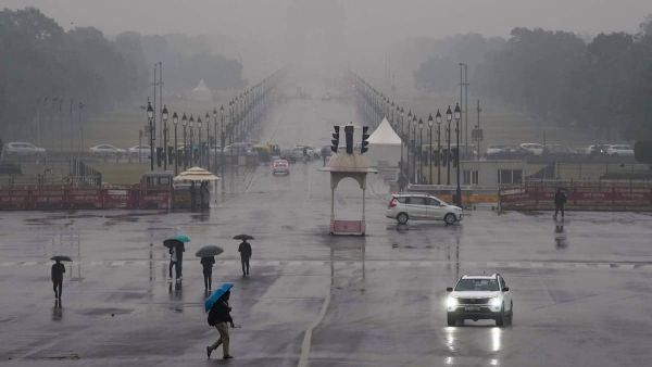
A sudden shift in weather patterns brought dark clouds, strong winds, and refreshing rain showers to various parts of the city, including the iconic Kushak Road and the Lutyens' Delhi belt.
#WATCH | Visuals from the India Gate after Delhi woke up to a pleasant change in weather with strong winds and rain. pic.twitter.com/nykZ6aSMDG
— ANI (@ANI) April 29, 2026
The capital has been under a "Yellow Alert" for heatwaves, with temperatures peaking between 42°C and 45°C over the last few days. However, as predicted by the IMD, a western disturbance triggered atmospheric activity that drastically pulled down the temperature within an hour.
The maximum temperature, which was expected to hit 41°C today, is now likely to settle closer to 38°C following the showers.
#WATCH | A resident of Delhi, Rajesh, says, "I feel so much better. The sun had been shining all day harshly. It was quite warm. This is a great relief..." pic.twitter.com/JQLe7lK3LB
— ANI (@ANI) April 29, 2026
According to the Regional Weather Forecast Centre (RWFC) in New Delhi, light to moderate rain accompanied by thunderstorms, lightning, and gusty winds of around 30-40 kmph was very likely across Delhi and surrounding areas during the morning hours.
The forecast said, "Light to moderate rainfall accompanied by light thunderstorm and lightning (30-40 Km/h gusty winds) is very likely to occur in the entire Delhi and NCR. Light to moderate rainfall accompanied by light thunderstorm and lightning (30-40 Km/h gusty winds) is very likely to occur at Sonipat, Rohtak, Kharkhoda, Charkhi Dadri, Mattanhail, Jhajjar, Farukhnagar, Kosali, Mahendargarh, Sohana, Rewari, Palwal, Narnaul, Bawal, Nuh, Aurangabad, Hodal (Haryana), Baraut, Bagpat, Meerut, Khekra, Modinagar, Pilakhua, Hapur, Gulaoti, Sikandrabad, Bulandshahar, Khurja (U.P.) Bhiwari, Tizara, Khairthal, Kotputli, Alwar, Viratnagar (Rajasthan)."
According to the Regional Weather Forecasting Centre (RWFC), light rain is expected across several parts of Haryana, including Jind, Panipat, Hisar, and Bhiwani, as well as Shamli in Uttar Pradesh. In the national capital, intermittent showers and strong winds have already transformed the weather, breaking the recent heatwave. Visuals from Kushak Road captured the shift, showing overcast skies and rain-soaked streets following the downpour.
#WATCH | Delhi: Weather turns pleasant in Delhi after days of scorching heat, with strong winds and light showers this morning. pic.twitter.com/HEiCopokYT
— ANI (@ANI) April 29, 2026
Despite the weather relief, environmental concerns persist; data from the Central Pollution Control Board (CPCB) recorded Delhi's Air Quality Index (AQI) at 260, maintaining its status in the "poor" category.
On Tuesday, India Meteorological Department (IMD) scientist Akhil Srivastava explained regarding a weather alert for the northern, eastern and western regions of India.
Srivastava said thunderstorm activity is expected in Punjab and Haryana over the coming days, which may lead to a drop in temperatures by 2-4 degrees Celsius.
#WATCH | Strong winds and rain showers bring a pleasant change in Delhi's weather, which has been grappling with intense heat wave conditions for the past days. Visuals from Kushak Road. pic.twitter.com/HU2JLsm2to
— ANI (@ANI) April 29, 2026
He added that an orange alert for thunderstorms has been issued for Bihar, Gangetic West Bengal, Odisha and Jharkhand, while heavy to very heavy rainfall is likely in northeastern India over the next week.
"In the northern region, a heatwave has been prevailing for the past 15 days. However, due to a western disturbance centred around 66° East longitude, thunderstorm activity is expected in the Western Himalayas and adjoining plains. Alerts have been issued for Jammu and Kashmir, Himachal Pradesh and Uttarakhand for thunderstorms and hailstorms. Punjab and Haryana may witness thunderstorms with wind speeds of up to 60 km/h, leading to a drop in maximum temperatures by 2-4°C over the next three days," Srivastava said.
On heatwave conditions and rainfall in the coming days, he said, "Heatwave conditions are likely in parts of Rajasthan, Madhya Pradesh, Vidarbha and Marathwada, but are expected to ease thereafter. Eastern India, including Bihar, West Bengal, Jharkhand and Odisha, is under an orange alert for severe thunderstorms, with wind speeds reaching up to 60 km/h and possible hail. Northeastern India is forecast to receive heavy to extremely heavy rainfall over the next week, with red alerts issued for Assam, Meghalaya, Nagaland, Manipur, Mizoram and Tripura."