
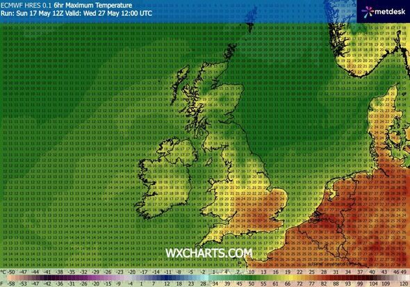
Scorching temperatures are set to blast Britain in a matter of days with two places in the south of England likely to see a sizzling 28C. New predictions from weather firm WXCharts have revealed central and south London may see the mercury spike higher than anywhere else in the nation on May 27 between midday and 6pm.
Elsewhere in the country, the south and east of England will get the lion's share of the hot temperatures with most areas seeing readings of around 25 to 27C, although coastal areas will be cooler.
In the North and the Midlands conditions will be cooler, with Yorkshire and Tyneside seeing a drop of over 10C compared to London. In parts of Scotland it is predicted to only reach 11C in some of the east and far noth, but Wales and Northern Ireland are expected to be warmer in the mid to late teens.
A forecast from the Met Office covering Wednesday May 27 said warm weather will "prevail", especially for the Bank Holiday weekend over May 23 to 25.
It said: "Saturday will be warm with some showery weather and even a chance of thunderstorms in places.
"Then by Sunday and through Bank Holiday Monday, warm and fair weather is expected to prevail.
"Through the following week, high pressure is expected to broadly remain in place for much of the UK, and fine weather is likely to continue for most of the country.
"There may be occasions where low pressure to the north may bring some brief spells of rain across northern parts, but in general fair weather will dominate.
"Temperatures are expected to be above normal, feeling very warm at times with light winds."
This Evening and Tonight:
Showers easing across eastern areas. Rain turning heavy in the west and spreading eastwards across all areas overnight. Turning increasingly windy, especially over the hills and around the coasts.
Tuesday:
Rain quickly clearing to leave a day of sunshine and frequent showers. Showers will be heavy at times, with hail and thunder. Remaining rather breezy. Temperatures around average once again.
Outlook for Wednesday to Friday:
Showers on Wednesday. These becoming confined to the northwest on Thursday. Turning increasingly humid on Friday, with thundery showers possible later in the day. Feeling much warmer in the sunshine.