An innovative cloud computing and machine learning technology developed by IIT Delhi researchers may assist in mapping the extent of a landslide using satellite data.
The ML-CASCADE tool is accessible to the public and is user-friendly. It needs the approximate date and location of a landslide incident.
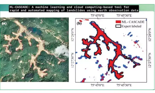
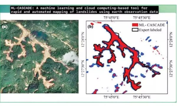
Within five minutes, the program can precisely map a complicated cluster of landslides. Additionally, it can map a basic landslide in two minutes, which is crucial for assessing damage after a catastrophe.
Large amounts of satellite, topographical, plant, and soil data were used to train the underlying model, which was published in the esteemed Landslides journal.
Prof. Manabendra Saharia of the IIT Delhi Department of Civil Engineering said, “Machine learning on geospatial data offers an unprecedented opportunity to overcome the drawbacks of index-based methods and integrate multiple diverse datasets to map landslides with high accuracy.”
According to Saharia, the conventional method of mapping landslides involves manually digitizing satellite images, which may be expensive, imprecise, and time-consuming. Large and isolated locations, however, are impractical for conducting field surveys and gathering geological data.
19 features with Sentinel-2 bands (pre- and post-landslide) and slope were used to create ML-CASCADE. In order to identify new landslide development, it also includes data from the NASA Digital Elevation Model, Normalized Difference Vegetation Index (NDVI), and differential Bare Soil Index.
The instrument is a machine-learning model that is dynamic and independent of previously taught models. Rather, it creates a unique model using information from the user and satellite photos. It adjusts to certain climatic conditions and local topography. Additionally, the tool’s user interface was created with input from both technical and non-technical users in order to provide disaster managers with a straightforward and useful tool. It is readily downloadable in a variety of image formats, which may then be shared or used for further GIS processing. Since Google Earth Engine serves as the backend, no data downloads are necessary.
On a local computer, the same results would take hours to create but just require minutes. Over thousands of landslides, including two significant ones in the Western Ghats (Kodagu landslide, 2018) and Himalayas (Kotrupi landslide, 2017), the research thoroughly validated the technique.
In order to create a national historical landslide inventory with geographical extents, the IIT Delhi researchers plan to use the technology. This inventory will be crucial for the development of landslide early warning systems. According to the researchers, mapping river inundation, deforestation, sand mining, and other environmental issues may also be done with the use of machine learning.