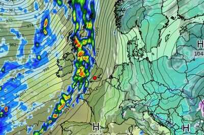
A huge 800-mile long band of heavy rain is expected to drench much of the UK in just a few days' time.
The incoming front is expected to cover almost all of mainland Britain in the early hours of Sunday February 23, stretching from Land's End in to Durness in the far north of . Much of this is expected to be torrential, according to maps from WXCharts, with many areas to the west seeing up to 10mm of rain per hour.
will be the first to experience the storm the previous evening before it sweeps across to the rest of the UK, eventually clearing to East Anglia and out towards the continent. This movement from the Atlantic will begin a wetter phase lasting several days, with more rain forecast every day through the last week of February. Some snow is also expected over higher ground in Scotland.
READ MORE:

In the meantime, one forecaster has warned of the return of wintry showers this coming weekend. James Madden from Exacta said in his latest forecast: "The models are now incorporating an area of precipitation that is likely to turn wintry or to snow in places through this weekend.
"This is likely to happen from the early hours of Saturday (February 15) across certain parts of the far north and west of the country, as these unsettled conditions coincide with colder conditions to deliver what could be a fairly decent snow event for Scotland throughout Saturday and the exact dates previously opted for that could also extend into some other parts of northern and northeast England on present indicators.
"Throughout Sunday we could also see an extension of these snow showers in these parts and potentially in some other parts to the east of the country and some other parts of northern and central England and Yorkshire before petering out later."
Colder temperatures are also forecast between now and the start of next week, with daytime highs of only 2-3C expected in many rural areas on Saturday. The warmest temperatures this weekend will be in Belfast, reaching 6 degrees Celsius, compared to 3C in Edinburgh, 5C in London and 4C in Cardiff.
Met Office weather outlook Tonight:Mostly dry with clear spells and a frost. However, rain, with brisk winds, edging northeast into parts of Northern Ireland, Wales and southwest England. Patchy snow or freezing rain possible.
Friday:Rather cloudy and breezy across Northern Ireland, Wales and southwest England with some rain and perhaps hill snow, reaching western Scotland later. Elsewhere frost clearing, then mostly fine. Still chilly.
Outlook for Saturday to Monday:Mostly dry, often cloudy and cold in the east and northeast. Weakening bands of rain and perhaps snow moving in from the west and southwest, where turning milder. Often breezy.