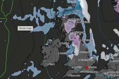
New weather maps show the areas of the country that could be hit by flurries of - just days after the clocks went forward and the UK basked in glorious sunshine. New maps from WXCHARTS, which uses MetDesk data, have shown a period of snow on April 13 that will stretch hundreds of miles from to Northern .
By midnight, the snow will extend from Inverness in northeast to Blackburn in Lancashire, North West England. There will also be other localised patches of the snow in the Scottish Highlands near the north west coast and North Yorkshire near the coast, reports .
In total throughout the day, five major cities will be affected: Inverness, , Edinburgh, , and Liverpool. The worst-affected areas in Scotland will include Cairngorms National Park, the Southern Uplands, and the Loch Lomand area, where levels will be around 1cm.
READ MORE:

England will also see similar amounts of snow in Carlisle, Northumberland, and the Yorkshire Dales. By 6am on April 13, the snow will persist, extending further south towards Manchester and into areas of North Wales, such as Bangor and Snowdonia. The snow will also fall at roughly the same rate, leading to accumulations of around 1cm in Scotland and North West England.
The ’s forecast for the period reads: “High pressure will tend to dominate through this period, often centred to the north or northeast of the UK, maintaining largely settled conditions for much of the time. This should result in lengthy spells of dry and bright weather, but with a risk of patchy overnight frosts where winds fall light.
There is also the chance of some areas of low cloud or fog, especially around some coasts. Later in the period, it may turn more unsettled at times as rain or showers try to push in from the west.
“It will be breezy at times, especially in the southwest early on. Daytime temperatures will tend to fluctuate depending on the wind direction and cloud amounts, with the potential for warm conditions at times but also cooler interludes.”
Meanwhile the start of April will be warm and sunny across the UK. After light rain clears the north of Scotland on Monday, there will be a consistently dry spell of weather for the whole of the UK.

Met Office Chief Meteorologist, Paul Gundersen, said: “The UK will have a sunny start to April this week. Temperatures will slowly build, with highs of 21-22°C possible by Thursday.
“Other than a small chance of some light rain grazing the far southwest of England it will be a dry week too. At this time of the year, we do start to see higher UV levels, so if you are outside enjoying the sunshine do think about protecting yourself from the sun as even in April it is strong enough to burn your skin.”
UK 5 day weather forecast Today:Plenty of sunshine for much of the UK, with any morning mist or fog patches soon clearing. Turning breezy in the south and west. Feeling warm in the sunshine, but fresh in the breeze, especially along coasts.
Tonight:A dry evening to come, with sunny skies ahead of dusk. Some low cloud and fog patches forming overnight. Chilly, with a patchy frost forming in the countryside.
Wednesday:Another warm and fine day for many, with plenty of sunshine across the country. Remaining breezy, particularly across central and southern parts of England and Wales. Cooler along coasts.
Outlook for Thursday to Saturday:The risk of showers in the southwest on Thursday. Elsewhere another dry and sunny day is expected. Hazy sunshine through Friday. Cloudier and cooler in the east on Saturday.