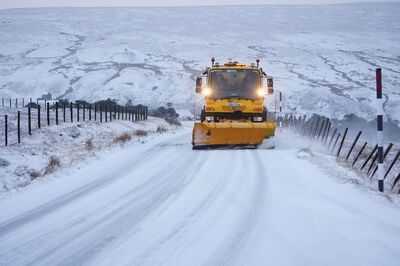
Millions of Brits face which is set to explode in their faces at the weekend, with several inches set to fall and spark chaos over the Easter weekend.
Concerning maps show the current spell of mild to will come to a sudden stop, with forecast to sweep across parts of the UK. According to WXCharts, parts of the Easter bank holiday weekend will be a snowy one for many in as the maps turn purple - showing heavy snow - from Saturday morning. The worst of the conditions will pass by the end of the day... but people within a massive 207-mile area will face a snowy day.
READ MORE:

The maps show the will stretch between Stranraer, in Dumfries and Galloway, up to Ullapool, close to Inverness, in the north of Scotland.
The is currently unable to confirm the conditions we will face at the weekend. However, its long range forecast reads: “Mixed conditions across the UK at the start of this period. Showers or longer spells of rain are likely across many regions, these heavy at times with a risk of hail and thunder, perhaps accompanied by strong winds.
“Some drier and brighter interludes are also likely at times, but probably with large amounts of cloud. Temperatures will likely be near normal overall. Into the following week, a similar pattern is likely at first with unsettled conditions at times with a risk of some heavy rain or showers.

“Later in the week settled weather is expected to become more prevalent, with more in the way of dry, sunny weather beginning to develop. Temperatures will probably be around normal or slightly above.”
For many more, particularly in the Midlands, North West and North East, part of Saturday will be a wet one with part of north Wales also set for a drenching.
It comes as forecasters stressed heavy rain could trigger travel disruption and power cuts in western Britain at the start of this week. According to the Met Office, disastrous flooding is expected to hit some areas between Tuesday and Wednesday.
In total, 37 areas have been plunged under a yellow weather warning. The alert is set from 12pm in the afternoon on Tuesday, until midday on Wednesday.
The said in a statement: "A spell of heavy and persistent rain is expected to move north across western Britain during Tuesday into early Wednesday. Whilst there is some uncertainty in where the heaviest rain will fall, 20-40 mm of rain is expected fairly widely.
"A few places may see 50-75 mm of rain during this period: gradually building up in the west following rain on Monday, whilst in parts of the east, falling in shorter periods where heavy showers and thunderstorms become slow-moving."