Advanced weather modelling maps show over 20C in as many as 24 counties as a 'mini ' takes hold across the UK. It comes as the says a "good deal of settled " is on the cards next month.
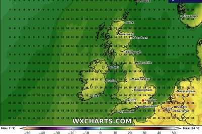
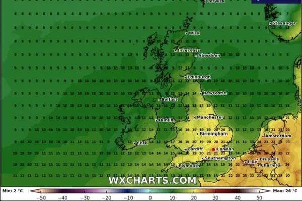
using the GFS model show temperatures in the UK should rise at the start of May. On May 1 the mercury could hit 20C in East Anglia at around midday, with highs of 18C or 19C felt quite wildly across much of the rest of and . Parts of and could see highs of around 17C.

Temperatures are expected to rise even higher on May 2 when the mercury could reach 21C across the south-east of England, including in , at around 6pm. The rest of England and parts of Wales could see highs of 19C to 20C.
READ MORE:
READ MORE:
However, temperatures are expected to be much cooler in both Scotland and Northern Ireland at the time, possibly only reaching 14C in Scotland's border regions. The mercury will struggle to rise much past 11C in Northern Ireland, according to the GFS weather model.
The Met Office is predicting average or slightly above average temperatures for the start of May. Its forecast for May 2 to May 16 states: "Early May will probably see a good deal of settled weather with high pressure patterns most likely to dominate. There are signs that towards mid May, pressure may fall in the vicinity of the UK, bringing an increased chance of rain or showers.
"Throughout this period, temperatures are expected to be near to a little above average, though some day to day and regional variability is to be anticipated."
Forecasters at Netweather say we can expect "predominantly dry and settled conditions" towards the end of April and at the start of May. Temperatures should rise to be "mostly above the seasonal norm", they predict.
The Netweather forecast for April 28 to May 4 states: "There is a general signal for above-average pressure over the British Isles, pointing to a greater than average likelihood of predominantly dry and settled conditions for much of the week, though again probably nothing like as relentlessly dry and sunny as we saw during the first third of April.
"Northerly and north-easterly winds may blow relatively frequently early in the week leading to near or slightly below average temperatures, but later in the week it will probably warm up, with temperatures ending up mostly above the seasonal norm during the second half of the week. The weather may turn more unsettled in the north-west late in the week as an Atlantic trough starts to move eastwards.
"Overall, this week will probably be warmer, drier and sunnier than average for the majority of the UK, probably 1 to 2C warmer than average, but the signal for high pressure is relatively weak, with some uncertainty over the extent to which low pressure systems may sometimes come in off the North Atlantic in between ridges of high pressure, so confidence in this outcome is not high, though it looks the most likely outcome at this stage."


