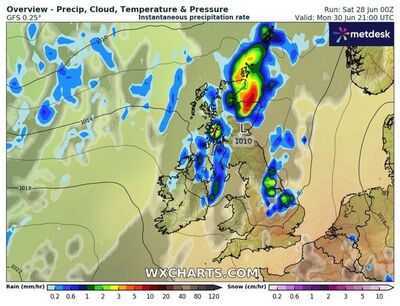
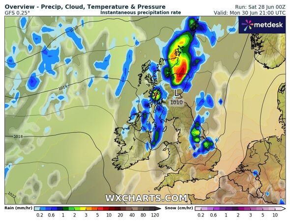
Hot and sticky temperatures reaching a melting 35C are set to break in a matter of days, with a wall of rain lashing down on more than 13 townsacross Britain. New weather maps from forecasters WXCharts show a band of wet conditions racing towards the country from Monday, June 30, into Tuesday, July 1.
In England, northern towns such as Gateshead, South Shields and Hexham are likely to see rain, and in Northern Ireland, Holywood, Carrickfergus, Whitehead, and Hillsborough could get a soaking. Central Scottish towns like Stirling, Ayr, North Berwick, Linlithgow, South Queensferry, and Dunfermline could also all see a drenching when the heat gives way to downpours.
The rainfall could bring welcome relief as it arrives on Monday evening, the day the Met Office predicts could beone of the hottest and humid 24 hours of the year so far. The national weather monitoring agency said temperatures are widely expected to exceed 30C in central and eastern England, "possibly reaching 34C in London and towards Cambridge."
Scroll down to view our interactive map to see what the temperatures will be like this weekend in your area.
Met Office presenter and meteorologist, Alex Deakin, said: "The weekend is going to be a hot one. For most of us, though, it's going to be a fairly grey start and it will be quite a damp start through central Scotland, parts of Northern Ireland.
"That rain should be edging away to the south, so Belfast cheering up, Glasgow, Edinburgh also looking brighter by the time we get to Saturday lunchtime, and a much brighter day overall for the Highlands of Scotland.
"Still quite breezy, quite a gusty wind blowing here. Quite a grey day over the far north of England, rain on and off across Cumbria. North Wales likely to see a bit of rain, particularly Anglesey at times. But a good chunk of England and Wales will stay dry and we'll have some sunshine, certainly for East Wales, much of southwest England, the Midlands and eastern England too. And it's in this eastern zone where we'll see the highest temperatures, likely to get up to 29, 30 degrees in and around the capital.
The UK Health Security Agency (UKHSA) has issued a number of amber and yellow alerts ahead of the extreme temperatures, warning of an "increased risk to health" and a "rise in deaths" among vulnerable groups.
The alerts cover seven regions in England and come into force at midday on Friday, June 27, and remain in place until 6pm on Tuesday, July 1.
The UKHSA says rising temperatures are likely to impact vulnerable groups, including those aged 65 and over or those with pre-existing health conditions. However, in areas placed under an amber alert, the health agency warns that younger people may also be affected by rising temperatures.
The Met Office expects temperatures in southeast England to peak at 26C on Friday, 28C on Saturday, 30C on Sunday and 34C on Monday.
Today:
Rather cloudy across western England and Wales with outbreaks of rain over the hills. Brightening up elsewhere with sunshine developing into the afternoon. Breezy for many, providing slight relief to the hot and humid conditions across central and eastern areas.
Tonight:
Most areas dry with clear spells. Cloudier in the west and more generally across northern England with occasional drizzle. Muggy for England and Wales; fresher for Scotland and Northern Ireland.
Sunday:
Cloud and drizzle drifting northwards, reaching northwest Scotland by evening. Chance of an afternoon shower across Northern Ireland as it brightens. Dry elsewhere and feeling warmer owing to lighter winds.
Outlook for Monday to Wednesday:
Hot and sunny for southern and eastern areas on Monday; cloudier and breezier in the northwest with rain. This cloud and rain gradually moving southeast, introducing fresher conditions by mid-week.