Friday, reaching Level 3 out of 5 on severe weather risk scale, especially south of Highway 20. The worst storms are expected from 3 to 7 PM. All types of storm hazards are possible. Temps today are 80–86°F, with southerly winds at 5–15 mph. Tonight, storms will weaken and move east. Lows will be 65–69°F with winds around 5–15 mph, as stated by the reports.
Saturday morning, some light rain may linger, but it’ll turn sunny later, with temps 78–84°F and breezy northwest winds. Saturday night will be dry with temps in the upper 50s to low 60s. Sunday will be mostly sunny with temps in the low to mid 80s, as per the report by KWWL.
Storm warnings and tornado alerts
Winds will be 5–10 mph from the west. Next week starts warm with Monday, but then storms will return midweek—cool down by Thursday— as per the reports.
ALSO READ: David Gergen, advisor to four U.S. Presidents and CNN commentator, dies at 83
Several tornado warnings were issued across southern Iowa, including Clarke County and Taylor County. One confirmed tornado was reported in Taylor County, but it has already lifted. The warning expired at 4:30 PM. A radar-indicated rotation triggered a tornado warning in Clarke County, affecting Murray and Osceola, as per the report by KCCI.
A landspout tornado was seen north of Clarinda, caught on video by viewer Eric Kline. As of 4:45 PM, all tornado warnings in southern Iowa have expired. A flash flood warning is active until 10 PM in parts of central Iowa — including Dallas, Polk, Madison, and Warren Counties, as per the reports.
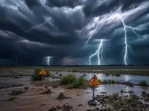
Heavy rain, flooding, and weather impact
These areas have already seen 1–2 inches of rain, with another 1–2 inches expected. Flooding may affect major places like Des Moines, West Des Moines, Indianola, Norwalk, and Altoona, plus key spots like the State Fairgrounds, Drake Stadium, and Adventureland, according to the report by KCCI.
Ames police reported flooded roads and warned people not to drive through standing water. Many cars got stuck. A severe thunderstorm watch is active in 17 counties in central and northeast Iowa, like Story, Boone, Marshall, and Tama, until 9 PM, as stated by the reports.
ALSO READ: Nancy Mace faces defamation lawsuit over sexual misconduct claims — government seeks legal immunity defense
A Tornado Watch is active until 8 PM for central and southeast Iowa, including Des Moines. Conditions are right for strong storms, heavy rain, strong winds, and maybe a few tornadoes. A tornado warning hit Newton and Ottumwa around 2:20 PM, but both expired before 3:15 PM, as per the reports.
At Iowa Speedway in Newton, IndyCar practice was paused due to tornado sirens. The severe weather risk is now shifting south and may exit the state soon. Flash flood warnings for central Iowa still continue until 10 PM Friday, according to the report by KCCI.
The Blank Park Zoo in Des Moines was closed due to a power outage, but it reopened by 10 AM today after power came back. More rain and storms are expected to reach the metro again Friday afternoon, but the worst storms are likely southeast of the area, as mentioned in the reports.
Yes, several parts of Iowa had tornado and flash flood warnings on Friday due to strong storms.
Q2. Which areas in Iowa were hit by tornado warnings today?
Clarke, Taylor, and Wapello Counties had tornado warnings, with one confirmed tornado in Taylor County.
Saturday morning, some light rain may linger, but it’ll turn sunny later, with temps 78–84°F and breezy northwest winds. Saturday night will be dry with temps in the upper 50s to low 60s. Sunday will be mostly sunny with temps in the low to mid 80s, as per the report by KWWL.
Storm warnings and tornado alerts
Winds will be 5–10 mph from the west. Next week starts warm with Monday, but then storms will return midweek—cool down by Thursday— as per the reports.
ALSO READ: David Gergen, advisor to four U.S. Presidents and CNN commentator, dies at 83
Several tornado warnings were issued across southern Iowa, including Clarke County and Taylor County. One confirmed tornado was reported in Taylor County, but it has already lifted. The warning expired at 4:30 PM. A radar-indicated rotation triggered a tornado warning in Clarke County, affecting Murray and Osceola, as per the report by KCCI.
A landspout tornado was seen north of Clarinda, caught on video by viewer Eric Kline. As of 4:45 PM, all tornado warnings in southern Iowa have expired. A flash flood warning is active until 10 PM in parts of central Iowa — including Dallas, Polk, Madison, and Warren Counties, as per the reports.
Heavy rain, flooding, and weather impact
These areas have already seen 1–2 inches of rain, with another 1–2 inches expected. Flooding may affect major places like Des Moines, West Des Moines, Indianola, Norwalk, and Altoona, plus key spots like the State Fairgrounds, Drake Stadium, and Adventureland, according to the report by KCCI.
Ames police reported flooded roads and warned people not to drive through standing water. Many cars got stuck. A severe thunderstorm watch is active in 17 counties in central and northeast Iowa, like Story, Boone, Marshall, and Tama, until 9 PM, as stated by the reports.
ALSO READ: Nancy Mace faces defamation lawsuit over sexual misconduct claims — government seeks legal immunity defense
A Tornado Watch is active until 8 PM for central and southeast Iowa, including Des Moines. Conditions are right for strong storms, heavy rain, strong winds, and maybe a few tornadoes. A tornado warning hit Newton and Ottumwa around 2:20 PM, but both expired before 3:15 PM, as per the reports.
At Iowa Speedway in Newton, IndyCar practice was paused due to tornado sirens. The severe weather risk is now shifting south and may exit the state soon. Flash flood warnings for central Iowa still continue until 10 PM Friday, according to the report by KCCI.
The Blank Park Zoo in Des Moines was closed due to a power outage, but it reopened by 10 AM today after power came back. More rain and storms are expected to reach the metro again Friday afternoon, but the worst storms are likely southeast of the area, as mentioned in the reports.
FAQs
Q1. Is there a tornado or flood warning in Iowa today?Yes, several parts of Iowa had tornado and flash flood warnings on Friday due to strong storms.
Q2. Which areas in Iowa were hit by tornado warnings today?
Clarke, Taylor, and Wapello Counties had tornado warnings, with one confirmed tornado in Taylor County.