Indian digital mapping company MapmyIndia has significantly enhanced its flagship navigation platform Mappls by introducing metro, railway, and bus route information within the app. With this update, users can now access public transport routes alongside private navigation features, making Mappls a comprehensive, multimodal mobility solution for urban commuters.
The new functionality is aimed at simplifying daily travel by allowing users to plan journeys that combine metro trains, local rail networks, and city bus services—all within a single, fully indigenous navigation app.
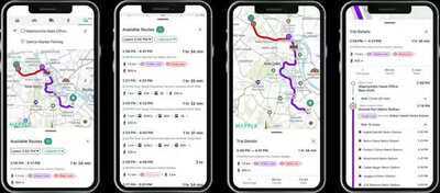
Public Transport Routes Now Available on MapplsAccording to MapmyIndia, the newly added public transport layer enables users to view route details, plan connections, and make informed travel decisions without switching between multiple apps. This integration strengthens Mappls’ position as an all-in-one mobility platform that blends private vehicle navigation and public transport planning seamlessly.
The company emphasized that this update reflects the growing demand for smart, sustainable, and accessible travel solutions in India’s rapidly expanding cities.
Cities Covered Under the New FeatureCurrently, the public transport routes feature is available in select major cities, including:
Delhi
Mumbai
Bengaluru
Chennai
Hyderabad
Pune
Kolkata
Ahmedabad
Chandigarh
Jaipur
Kochi
Indore
Bhopal
Nagpur
Patna
Lucknow
Kanpur
Agra
MapmyIndia has stated that more cities will be added in phases, expanding coverage across urban and semi-urban regions.
Platform Availability and Rollout PlanThe multimodal public transport feature is currently live on iOS devices and the web version of the Mappls app. The company has confirmed that the Android rollout is expected shortly, ensuring wider access for users across platforms.
Once fully deployed, the feature will cater to millions of daily commuters who rely on public transport for work, education, and essential travel.
Works Alongside Existing Navigation ToolsThe newly introduced public transport routes complement Mappls’ existing capabilities, which include:
Turn-by-turn navigation
Real-time traffic updates
Safety alerts
Intelligent route suggestions
Location-based services
By combining these tools with public transport data, Mappls aims to offer end-to-end journey planning, allowing users to choose the most efficient, cost-effective, and eco-friendly routes.
Encouraging Sustainable Urban MobilityMapmyIndia believes that making public transport information easily accessible can help reduce traffic congestion, fuel consumption, and carbon emissions. The company sees this update as a step toward promoting mass transit adoption and cleaner urban environments.
As Indian cities struggle with increasing vehicle density and pollution levels, digital tools that support public transport usage are becoming increasingly important.
What MapmyIndia Leadership SaysCommenting on the launch, Rakesh Verma, Co-founder, Chairman, and Managing Director of MapmyIndia Mappls, said the update was developed by closely listening to user feedback.
He stated that the company aims to make Mappls more inclusive and accessible for every citizen. As a platform built in India for Indian users, Mappls remains committed to supporting sustainable, technology-driven urban mobility by integrating public transport into everyday navigation experiences.
A Step Toward Smarter, Cleaner CitiesWith the addition of metro, rail, and bus routes, MapmyIndia Mappls is positioning itself as a future-ready mobility platform. The company encourages citizens to explore public transport options through the app, helping reduce pollution while making city travel more efficient and predictable.