As much as 31 inches of snow could descend within a 24-hour period later this month, with millions of Brits preparing for another blizzard.
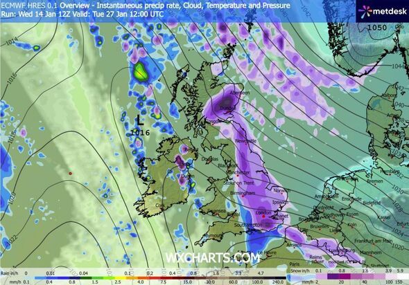
Advanced weather prediction maps indicate that snow will sweep across Northern Ireland, Scotland, Wales and England around midday on January 26, initially bringing significant flurries to the central and northern regions. Cities including Birmingham, Manchester, Edinburgh and Glasgow should all anticipate some snowfall.
The blizzard is forecast to persist until midday on January 27. Early morning maps for this date show flurries in the north and east, with East Anglia likely to experience some snow at this time.
Light snowfall is also a possibility in Northern Ireland.
By midday on January 27, the ECMWF weather model predicts snowfall in the south-east of England, with London and Essex particularly at risk. According to the maps, snow could fall from the south coast right up to the far north of Scotland.
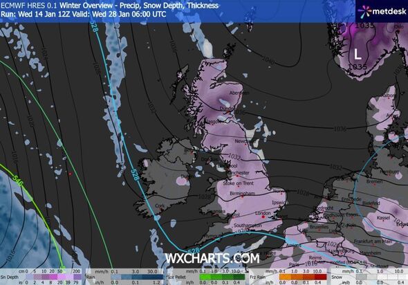
Snow coverage maps for January 28 reveal the full impact of this wintry weather onslaught, with snow settled across almost the entirety of the UK. Only Northern Ireland, parts of Wales and the far south-west of England are shown to be free of snow on the ground around 6am.
Snow depth charts suggest that as much as 79cm (31 inches) could settle in the Scottish Highlands, with 34cm (13 inches) possible in northern England and 7cm (three inches) predicted in the south-east.
The Met Office has warned that the weather could turn colder this month, increasing the likelihood of snowfall in parts of the UK. The national weather service's forecast for 19 to 28 January reads: "Throughout this period, the UK will see a battle between Atlantic weather systems attempting to arrive from the west while high pressure and colder conditions attempt to exert some influence from the east.
"Initially, milder Atlantic air is expected to dominate. This should maintain changeable conditions with showers or longer spells of rain for most. The wettest weather in western parts of the country, drier in the east.
"Temperatures overall likely to be around average. Later in the period, there is an increased chance that conditions will turn colder. This aspect of the forecast is still somewhat uncertain but the potential transition to colder weather also increases the chance of snow across parts of the country."
BBC Weather's forecast also hints at the possibility of "wintry showers", with "cold easterly flows" potentially moving in. The BBC's forecast for the coming week states: "There are some signs that the high pressure centred over and near Scandinavia and the Urals could strengthen and build more towards north-west Europe, holding Atlantic systems farther west or pushing them northwest and south-east of the UK.

"This could bring some colder easterly flows by the end of the week, with the chance of some wintry showers coming off the North Sea. Bear in mind, however, the milder Atlantic-driven weather regime could win out, even if only in western regions."