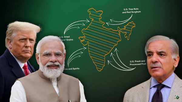
The interim trade agreement between India and America was announced on Saturday, but it was not the tariffs or the terms of the deal that grabbed the headlines, but a photo. The map of India published in the document issued by the Office of the US Trade Representative (USTR) silently made both Pakistan and China uncomfortable and brought a political smile in New Delhi.
In this map, the entire Jammu and Kashmir, including Pakistan Occupied Kashmir (PoK), is clearly shown as a part of India. Not only this, Aksai Chin, claimed by China, was also shown within the Indian border.
From tree nuts and dried distillers grains to red sorghum and fresh and processed fruit, the US-India Agreement will provide new market access for American products. pic.twitter.com/mqpP10LJp1
— United States Trade Representative (@USTradeRep) February 6, 2026
Till now, America and its State Department have often released such maps in which PoK was shown as dotted line or disputed area so that Pakistan does not get angry. But this time there is no twist, the entire Jammu and Kashmir is directly shown as a part of India.
Showing Aksai Chin as a part of India in the map is an eyesore for China too. Beijing has been claiming this area for a long time. India has many times raised objections to the wrong drawing of borders in front of America and international organizations, especially regarding Jammu-Kashmir and Arunachal Pradesh. This time it seems as if America has listened to India.
The timing of this entire incident is no less interesting. India-US relations have not been easy in recent months. Trump had imposed tariffs of up to 50% on India, which was the highest among American allies. Now under the interim trade deal, these have been reduced to 18%, which is said to be the lowest in Asia. Meanwhile, Trump has also been accused of joining India-Pakistan in hyphen again. In such an environment, this map became not only a relief for India but also a silent win.