
Temperatures across the UK are about to rapidly pick up, according to weather maps by forecaster WXCharts. The maps generated using Metdesk data have highlighted parts of the nation in yellow, indicating the warmer conditions expected very soon.
It comes shortly after most of the UK has been experiencing harsh conditions, with the Met Office issuing warnings for parts of the nation over the weekend, and Storm Dave bringing very strong winds and wet conditions.
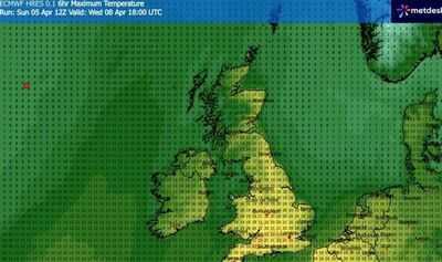
However, according to recent weather forecasts from WXCharts, conditions will improve by Wednesday, April 8, with temperatures reaching 22C.
The dramatic U-turn in the weather is a mini heatwave, as the Met Office defines it as an "extended period of hot weather relative to the expected conditions of the area at that time of year".
Berkshire, Wiltshire, and Somerset will see the highest temperatures of 22C on the day, though much of the south and East of England will see temperatures hover between 18C and 21C.
The Midlands and north of England will also welcome balmy weather, with temperatures across the Midlands averaging around 20C, while northern England will see it range between 16C and 19C.
Along with the warmer temperatures, conditions are expected to remain fairly dry throughout the day. The following day is also expected to be warmer; however, the warmer temperatures will be confined to the South-east and East of England, rather than being widespread as expected on April 8.
You can find the list of areas that will be hit by the warmer temperatures below: