
Specialists are cautioning that a rare natural climate phenomenon is developing this year, pushing global temperatures higher and potentially delivering severely unpredictable weather to the UK.
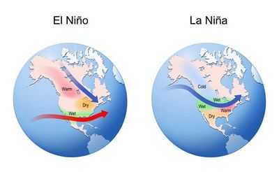
El Niño is a natural climate phenomenon characterised by warmer surface waters across the central and eastern Pacific, triggering shifts in global weather patterns.
This takes place when the temperature rise reaches at least 0.5 degrees Celsius above average across the central and eastern equatorial Pacific.
AccuWeather Long-Range Forecaster Paul Pastelok explained that El Niño itself is not a single storm, but rather a large-scale climate driver that can skew the odds towards particular weather patterns.
"An El Niño is not a storm. It does not affect you directly. It is a cycle that contributes like many other factors to produce weather changes and sometimes extremes," he said.
The El Niño phenomenon alternates in cycles with its counterpart La Niña. There have been 27 El Niños since 1950, occurring on average every three to four years, according to The Weather Channel.
Experts have cautioned that a super El Niño is becoming increasingly likely later this year, potentially carrying significant global consequences for rainfall and temperatures from summer through to winter.
The National Oceanic and Atmospheric Administration has placed a 25 percent probability on El Niño intensifying into a super El Niño by autumn or early winter.
A super El Niño occurs when warm ocean anomalies reach at least 2 degrees Celsius. These intense El Niños are more rare, with only five since 1950. The last super El Niño occurred 11 years ago from 2015-16.
Every El Niño is different, The Weather Channel reported, but generally, the stronger the El Niño, the more likely its typical impacts on global weather will happen.
Potential impacts of a stronger El Niño include:
A stronger El Niño can also heighten the risk of impactful storms later in the year.
For the UK, this may mean anything from unseasonably warm spells to periods of heavy rainfall It can also influence storm tracks across the Atlantic, potentially affecting how and where winter storms develop, according to The Standard.
The global temperature signal tied to El Niño may not peak immediately. While the pattern is expected to develop this year, the highest global temperatures linked to it would more likely occur in 2027 rather than 2026.
While uncertainty remains over just how powerful the event ultimately becomes, confidence is growing that El Niño will take hold.
"We will likely see at least a moderate El Niño, but more likely a strong El Niño," said AccuWeather Senior Meteorologist Chad Merrill.