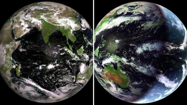
Russian space agency Roscosmos has released a striking new image of Earth captured by its Electro-L hydro-climate satellite. In those breathtaking images, India can be seen glowing green from space. Electro-L is a space-based weather-observation instrument designed to keep a permanent, unwavering eye on our planet. Electro-L is a Russian weather satellite deployed in geostationary orbit.
Big surprise for iPhone and iPad users! This amazing game is finally launched, now on mobile experience the console-like thrill
Electro-L is fixed at a fixed point about 36,000 kilometers above the Earth’s equator and rotates at exactly the same rate as the planet’s rotation. It is as if he is playing his role as a watchman. He never moves. (Photo Courtesy – X)
This image, released by Roscosmos, was taken using the Multispectral Scanning Device. It is a camera that can see many types of light at once. Its scope includes the Indian Ocean as well as Eurasia, Africa, Australia and Antarctica. The Electro-L satellite does not see the world as your eyes do. It captures images in 10 spectral bands, which are channels of light at different wavelengths.
Security of bank accounts at risk? Nirmala Sitharaman warned, concern increased due to AI
A full-body view of Earth captured by Russia’s Electro-L satellite, with the Indian subcontinent in the center, Sri Lanka clearly visible below, and the dark, blue waters of the Indian Ocean all around.
In this view, centered over the Pacific Ocean and Southeast Asia, the ‘Electro-L’ satellite captured the dark green of the Philippine archipelago and the rust-red interior of Australia, as well as massive storm systems over the open ocean.