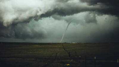
On Sunday, intense thunderstorms and tornadoes impacted regions of South Dakota and Nebraska, leading to urgent alerts from meteorological authorities and leaving many residents without power. A storm observer noted a tornado touchdown southeast of Scotland, which was particularly concerning as it was rain-wrapped, making it hard to see and assess.
In southeastern South Dakota, numerous power outages were reported following the passage of severe thunderstorms in the afternoon. The hardest-hit areas included Yankton and Bon Homme counties, close to the Nebraska border, where strong winds likely caused damage to power lines and electrical systems.
The storms were characterized by destructive winds, heavy rainfall, and frequent lightning as they moved eastward. Utility teams were anticipated to continue evaluating the damage and restoring electricity throughout the evening.
Additionally, the National Weather Service issued a Particularly Dangerous Situation (PDS) tornado warning for central Nebraska after a large and extremely dangerous tornado was confirmed near St. Libory, approximately 15 miles north of Grand Island. Meteorologists indicated that this tornado was traveling northeast at about 45 mph (72 km/h), posing a threat to Nance, Merrick, Polk, and Howard counties.
Officials described the conditions as life-threatening, warning that the storm could lead to catastrophic destruction, including the obliteration of homes, vehicles, and mobile homes. Another tornado warning was also active for parts of central Nebraska after storm spotters confirmed a second tornado near the Hall and Howard County line, located about 14 miles northwest of Grand Island, moving northeast at around 35 mph (56 km/h).
Forecasters cautioned that the storm could produce hail as large as two inches in diameter. The National Weather Service alerted that flying debris could be lethal for anyone outdoors, and mobile homes were particularly vulnerable to severe damage or total destruction. Additional risks included roof damage, downed trees, and vehicle destruction in the affected areas.