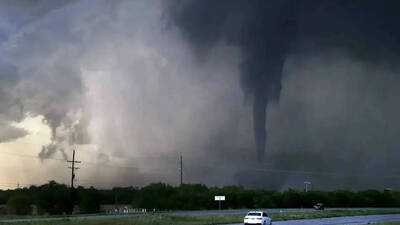
A Tornado Watch has been announced for several counties in Missouri and Arkansas, with parts of Canada also preparing for a significant weather event this Sunday. The Storm Prediction Center has issued this watch for a broad area in the Ozarks, effective until 7 p.m. on Sunday, according to reports from local news sources. The counties affected in Missouri include Barry, Cedar, Christian, Dade, Dallas, Greene, Hickory, Lawrence, McDonald, Polk, St. Clair, Stone, Taney, and Webster. In Arkansas, the watch covers Benton, Boone, Carroll, Marion, Newton, and Searcy counties.
Residents in these regions are advised to revisit their emergency plans, ensure their supplies are adequate, and identify a safe space within their homes. A Tornado Watch indicates that tornadoes could form in the area, and conditions are conducive to their development.
Canada Facing Serious Threat Too
Meanwhile, Environment Canada has issued a Tornado Watch for southeastern Saskatchewan and parts of Manitoba, including Estevan, Carnduff, and Moosomin, as reported by CTV News. The threat level is considerable, with wind gusts reaching up to 120 kilometers per hour, hail potentially measuring nine centimeters in diameter, and rainfall surpassing 50 millimeters.
Officials from Environment Canada have indicated that severe weather, including the risk of tornadoes, is expected to persist into the evening. They have cautioned that significant damage to homes, infrastructure, and the environment is likely. Those near water bodies are advised to remain vigilant and seek shelter on land if threatening weather approaches.
What Each Alert Level Means
As severe weather impacts various regions, it is essential to comprehend the meanings of different alert levels. A Tornado Watch signifies that tornadoes are possible in the vicinity. This is the time to review emergency plans, check supplies, and ensure safe rooms are prepared. While immediate action is not required, staying informed and ready to act quickly is crucial.
A Tornado Warning indicates that a tornado has been sighted or detected via radar. This is a critical situation; individuals should move to an interior room on the lowest floor of a sturdy building, away from windows. Those in mobile homes, vehicles, or outdoors should seek the nearest solid structure as quickly as possible.
The highest alert level, a Tornado Emergency, is issued when a violent tornado has touched down, causing or threatening catastrophic damage. In this case, individuals must find the safest shelter immediately and should not attempt to outrun a tornado in a vehicle.