A 430-mile long wall of rain may hit much of the UK in a few days' time, the latest weather maps show. If the charts prove correct this far out, then a large swathe of Britain will get a soaking from around Stirling in the north to Bournemouth in the south and almost everywhere in between.
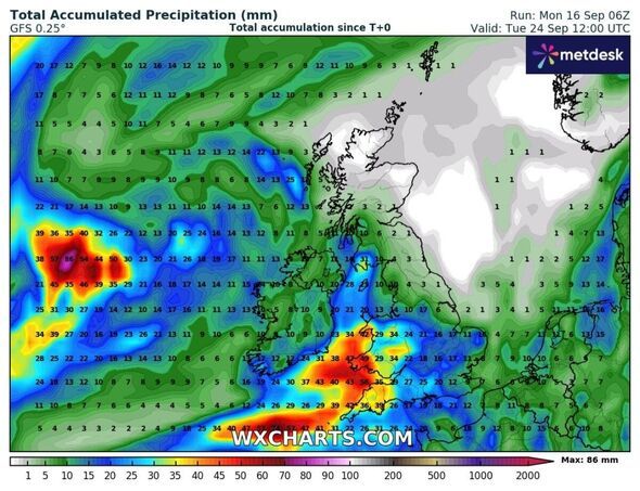
Maps generated using Metdesk data from WX Charts show several millimetres of rain falling per hour at midday on Tuesday, September 24.
Jim Dale, founder and senior meteorologist at British Weather Services told Express.co.uk Brits can expect more wet weather later this month.
He said: "It will be cooler not colder, wetter not drier. [We're] back to taking in our breaths from the Atlantic, especially for the north and west of the country. Call it standard fayre!"
It will come after a short, sharp heat blast covering much of Britain this week - with dry conditions set to become wet by the end of the month.

The Met Office's long range forecast (September 21-30) expects settled but often cloudy weather across many central and northern areas, with the best of the sun to the west of high ground.
It added: "Most places away from North Sea coasts will see above average temperatures through the weekend. Early next week, the risk of showers and thunderstorms will reduce across the south, with a very short-lived settled spell likely as the transition occurs.
"Following this transition areas of cloud, rain and stronger winds are expected to push in from the west once again, but the focus for this heavy rain is likely to be across the southern half of the UK, with more settled conditions perhaps holding on for the longest in the north."
Weather maps show total accumulated rainfall up to 56mm in the Bristol Channel by midday on September 24. Totals may rise to 47mm along stretches of the west Wales coast, while coastal parts of north Cornwall could see 42mm.
This compares to just 1-3mm along the coast of north east England and southern Scotland, 2mm around Hull and some 15mm on the north Norfolk coast.
 Met Office UK five day weather forecast
Monday, September 16 - Friday, September 20
Headline: Fog clearing through the morning but plenty of sunshine.
Today: Thick fog across the northwest of England through the morning but lifting by lunchtime. Plenty of sunshine elsewhere with some cloud towards the northwest of Scotland. Feeling warm in the sun, especially in the south where winds are light.
Tonight: Light rain and drizzle moving into the northwest, possibly heavy across Northern Isles. Patchy cloud in the southeast later, but clear spells elsewhere with patchy mist and fog.
Tuesday: A fine start with fog restricted to Northern Ireland and northeast England. Cloudier in the northwest with some drizzle. Sunny elsewhere and feeling warm.
Outlook for Wednesday to Friday: Largely fine through much of the week, though an easterly breeze developing which may introduce patchy cloud.