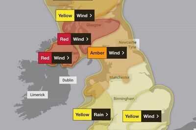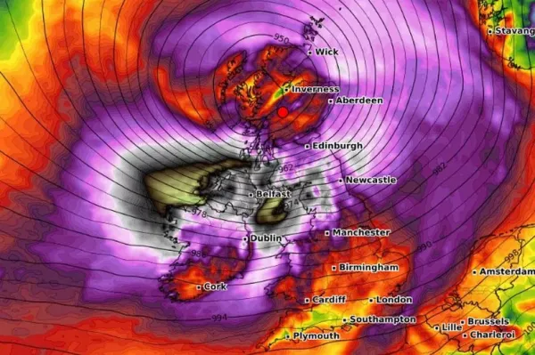
Terrifying have shown the areas of the UK which will be hit hardest by in the coming hours and days.
The has declared red warnings for areas of Northern Ireland and for Friday, although the rest of the country is under either yellow or amber alerts at some point. It has been declared a “multi-hazard event”, meaning there will be snow, rain and very strong winds - depending on where you are.
Maps from WX Charts have shown where will be hit by the hardest winds. Several locations, such as Newcastle and Carlisle in northern England, as well as Edinburgh, Glasgow and Aberdeen in Scotland could face huge winds of more than 100mph.
READ MORE:

The worst winds will bring danger to life with very dangerous driving conditions as trees could be felled and the potential of damage to homes where power could be lost. By the coast, large waves are feared and roads, bridges and railway lines will be closed.
Further south, cities including , Liverpool, Hull, Birmingham, Cardiff and London could be hit by just as terrifying winds of around 75-80mph. The north west and Wales is under an amber alert, while a yellow warning can be found over the rest of the country.

Met Office chief meteorologist Paul Gundersen said: “We reserve the issuing of Red Warnings for the most severe which represents a likely danger to life and severe disruption, and that is the case with Storm Éowyn.
While it will be widely very windy on Friday, with additional hazards from rain and snow, the strongest winds and most significant impacts are likely in Northern Ireland and central and southwestern parts of Scotland within the Red Warning areas, where winds could gust 80-90 mph quite widely for a time, and potentially up to 100 mph for exposed coasts in particular.
“Storm Éowyn is a multi-hazard event, with snow likely for some, rain for many and strong winds for much of the UK. As a result, a number of weather warnings have been issued, with all parts of the UK covered by one warning at some point on Friday.
“Storm Éowyn is expected to cross Northern Ireland early on Friday morning. It will then continue northeast across the northern half of Scotland during Friday afternoon and is expected to be centred near Shetland during Friday evening.
“It’s important to note that even those away from the immediate Red Warning areas will still likely see disruptive weather, with travel plans likely to be severely impacted, as well as the possibility of power cuts for some.”