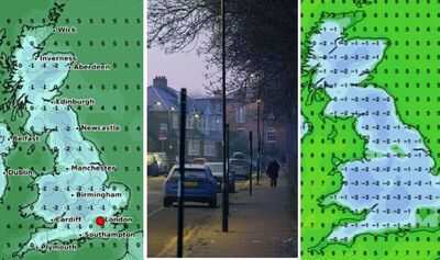
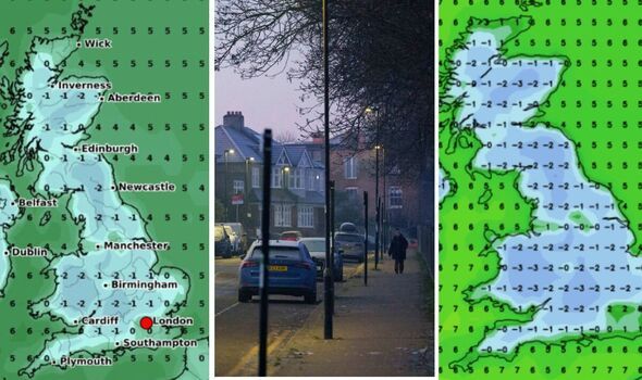
have turned white as a -3C blast is set to hit the UK. has begun, and the clocks have been put forward, but this does not spell the end of the chilly weather, forecasters predict. On April 16 at 6am, maps generated by WX Charts using Met Desk data suggest that subzero temperatures will be recorded across the country, apart from much of the coast and the south east around . The mercury will read -2C or -3C around the Cotswolds and the bottom of the West Midlands.
The middle of Wales will also be affected by the coldest temperatures. Its extremities, however, such as Anglesey, will feel a tad warmer than elsewhere, though still cold. Parts of Merseyside and Yorkshire, though, will be slightly warmer, experts say. The same goes for the very tip of Scotland, including its islands to the north and off the west coast, and the south western and East Anglian coasts. In addition, the Isle of Man and the Northern Irish coasts look set to avoid freezing temperatures.

The Met Office has issued a long-range forecast for between April 15 and 29, and experts warn of cold nights.
They said: "Weather patterns are most likely to remain fairly slow-moving through the second half of April.
"High pressure may remain centred to the north or northeast of the UK, potentially bringing more fine and dry weather.
"However, there may also be some interludes of rain or showers, these perhaps more likely to affect southern and western parts of the UK.

"Temperatures are likely to be around or a little above average overall, and feeling warm inland at times during the day, although some chilly nights are still possible under any clear skies."
Weather expert Jim Dale that, once we are out of this week, it'll "turn noticeably colder for a spell", with frosts "returning for many".
He added: "That's April for you!"